Video: Google Maps vs Google Earth — What are the Differences?
- The Historical Background: Origins of Two Google Tools
- Platform Availability in 2026
- Visual Differences: 2D Maps vs 3D Globe
- Feature-by-Feature Comparison
- Google Maps vs Google Earth — Side-by-Side Comparison Table
- The Data Power of Google Maps for Business
- Who Uses Google Earth? Real Professional Use Cases
- Google Earth Pro: Professional Features Worth Knowing
- Google Earth vs Google Maps for Developers
- The Verdict: Which Tool Should You Use?
- Frequently Asked Questions
I get this question at least once a month. Usually from someone who's been using Google Maps for years and suddenly realizes Google Earth exists. "François, aren't they the same thing?" No. They're really not. And picking the wrong one can waste a surprising amount of your time.
Over 1 billion people use Google Maps every month (source: Statista). Google Earth doesn't even publish its user numbers — its mobile app sits at 3.8 stars across roughly 2.95 million reviews (July 2026), which is respectable but nowhere near the scale of Maps. That gap tells you something. But lower popularity doesn't mean useless. The difference between Google Maps and Google Earth goes way deeper than most people think, and depending on what you're trying to accomplish, Earth might actually be the better pick.
I'm not the only one who fields this question, by the way. There's a whole r/explainlikeimfive thread titled "ELI5: difference between Google Earth and Google Maps" — genuinely confused people, lots of them. And over on r/GoogleMaps, somebody posted "I thought Google Maps and Google Earth shared the same data…" Spoiler: they don't, not fully. So if you've ever typed "google maps vs google earth reddit" into a search bar at 11pm, you're in good company.
We're going to compare them on everything that matters — platforms, visuals, features, business data, developer tools. And if you're doing anything related to B2B prospecting, pay attention around the middle of this article. There's something most people miss entirely.
The Historical Background: Origins of Two Google Tools
Google Earth wasn't built by Google. Lot of people don't know that.
It started life as EarthViewer 3D, made by a company called Keyhole Inc. And here's the weird part — Keyhole was partially funded by In-Q-Tel, which is the CIA's venture capital arm. Yeah, the CIA. Google bought Keyhole in 2004, slapped their name on it, and launched Google Earth in 2005 (source: Google official blog).
Google Maps also launched in 2005, but from completely different roots. Maps was built to solve a simple problem: help people get from A to B without printing MapQuest directions. Earth was built to let you explore the planet from your desk. Two different missions. Two different teams. They just ended up under the same logo.
This matters because it explains basically every decision Google made after that. Maps got real-time navigation and route planning. Earth got satellite imagery layers and KML file support. That split? It's still there in 2026. Twenty years later and they're still fundamentally different tools.
Platform Availability: Where You Can Use Each Tool in 2026
Google Maps: web browser, mobile app. That's the whole list. It comes pre-installed on every Android phone — you literally can't avoid it. Nobody downloads Google Maps. It's already on your phone before you even set up your email. For a lot of people it's also just the best free GPS map they've never had to think about.
Google Earth: web, mobile app, and a desktop application called Google Earth Pro. Three options instead of two. That desktop version matters a lot — more on that later.
Something that annoys me every single time: I open Google Maps in a private window and boom, it knows where I am. Instant. I open Google Earth? I'm staring at somewhere in the Atlantic Ocean near the Greenwich Meridian. I have to manually click a button to find my own location. You might say, François, it's no big deal, that's just a detail. But actually it tells you exactly who these tools are for. Maps assumes you're in a rush. Earth assumes you've got time to wander.
(Google Earth for Web has gotten better since 2017, I'll give them that. Smoother, faster. Still nowhere near the Google Earth Pro desktop version for anything serious though.)
Visual Differences: 2D Maps vs 3D Globe
Most people skip over this and they really shouldn't.
Google Maps = flat 2D map. Google Earth = 3D globe. Sounds cosmetic. It's not. The consequences for how you see geographic data are massive.
Open Google Maps and look at Greenland. It looks enormous — maybe the size of Africa, right? Now switch to Google Earth. Greenland shrinks to what it actually is: about 836,000 square miles compared to Africa's 11.7 million. Fourteen times smaller. Maps was lying to you the whole time.
The culprit is the Mercator projection — the mapping system Google Maps uses. Great for preserving angles, which is why it works for navigation. Terrible for representing actual sizes. Everything near the poles gets inflated. Google Earth doesn't have this problem because it shows you an actual sphere.
If you're driving to the grocery store, none of this matters. But for geographic research? Environmental analysis? Even just understanding how big countries really are relative to each other? The difference between Google Earth vs Google Maps resolution and proportional accuracy is hard to overstate.
Feature-by-Feature Comparison
OK let's stop dancing around this and compare them directly.
Navigation & Directions
Not even close. Maps destroys Earth here.
Real-time traffic. Turn-by-turn voice navigation. Transit schedules — bus, train, ferry, whatever. Offline maps for when you're in the middle of nowhere without signal. Estimated arrival times that factor in current accidents and construction. I did a whole comparison between Google Maps, Apple Maps and Waze recently, and even against dedicated navigation apps, Maps holds up.
Video: Google Maps vs Apple Maps vs Waze
Google Earth for navigation? It doesn't do navigation. At all. You can look at roads from space, which is cool, but try asking it to route you to the nearest gas station. Nothing happens.
Local Business Discovery & Reviews
I ran a test last week. Searched "restaurant" on both platforms, same city, same time.
Google Maps gave me everything. Pins with star ratings, a scrollable list, photos of the food, menus, opening hours, phone numbers, websites, how busy the place is right now, individual reviews going back years. Over 225 million businesses are indexed on Google Maps across 195 countries (source: Scrap.io data, July 2026). It's absurd how much data is in there.
Google Earth? I got pins. A much shorter list. Business name, address, phone number. That's about it. No reviews. No hours. No menu.
For finding businesses, checking reviews, or doing any kind of local research — Maps, every time. And that database isn't just for finding dinner spots. It's what powers serious B2B prospecting at scale. But I'll get to that.
Satellite Imagery & Historical Data
This is where Earth finally gets to fight back. And it wins convincingly.
Google Earth lets you scrub through a timeline of historical satellite imagery. You can watch a neighborhood get built over fifteen years. Track how a coastline eroded. See a forest disappear. The images come from Landsat, Copernicus, Airbus, Maxar — serious satellite providers (source: Google Earth attribution). Plus there's the Timelapse feature, which compresses decades of change into a few seconds of animation. Genuinely impressive.
Google Maps has a satellite view, sure. But it's a single snapshot. No timeline slider. No historical comparison. If you need to track how places change over time — Google Earth historical imagery vs Google Maps? Earth wins and it's not even a conversation.
3D Visualization & Street View
Street View is available on both — Google's captured 170+ billion images across 100+ countries (source: Google). Call it a tie there.
3D is more nuanced. Earth has detailed photogrammetry models of hundreds of cities. Tilt, rotate, fly through — it's been doing this for years. Maps recently started rolling out "Immersive View" in select cities, and it looks great, but coverage is still limited. For Google Earth vs Google Maps street view and 3D capabilities overall, Earth has the edge simply because it's been doing it longer with better coverage. Also: if you work with KML files at all, Earth is your only option.
Google Maps vs Google Earth — Side-by-Side Comparison Table
I know some of you scrolled straight to this. Here's everything in one place.
| Feature | Google Maps | Google Earth |
|---|---|---|
| Primary Purpose | Navigation, local search, business discovery | Geographic exploration, research, education |
| Interface | 2D flat map (Mercator projection) | 3D interactive globe |
| Platforms | Web, Mobile (iOS/Android) | Web, Mobile, Desktop (Earth Pro) |
| Navigation | ✅ Full with real-time traffic | ❌ None |
| Business Data | 225M+ businesses, reviews, hours, contact info | Basic names and locations only |
| Satellite Imagery | Static snapshot (no timeline) | Historical imagery with timeline scrubber |
| Street View | ✅ Full integration | ✅ Available |
| 3D Buildings | Immersive View (limited cities) | Full photogrammetry, many cities |
| Offline Access | ✅ Downloadable offline maps | Limited |
| KML Files | ❌ | ✅ Full import/export |
| API | Places API, Directions API, etc. | Google Earth Engine |
| Pricing | Free (API has usage costs) | Free (Pro free since 2015) |
| Monthly Active Users | 1 billion+ | Not disclosed (much smaller) |
| Best For | Daily nav, B2B prospecting, local SEO | Research, education, environmental analysis |
The Data Power of Google Maps for Business
This is the part most comparison articles completely ignore. And honestly, it might be the most important section here if you're running a business.
Google Maps isn't a map. I mean, it is, technically. But it's also a database of 225 million+ businesses (225,676,406 indexed as of July 2026, to be exact). Think about that number for a second. Two hundred and twenty-five million. And 46% of all Google searches have local intent (source: Think with Google) — meaning almost half the searches people run on Google are looking for something nearby. A dentist, a plumber, a taco place that's open past midnight.
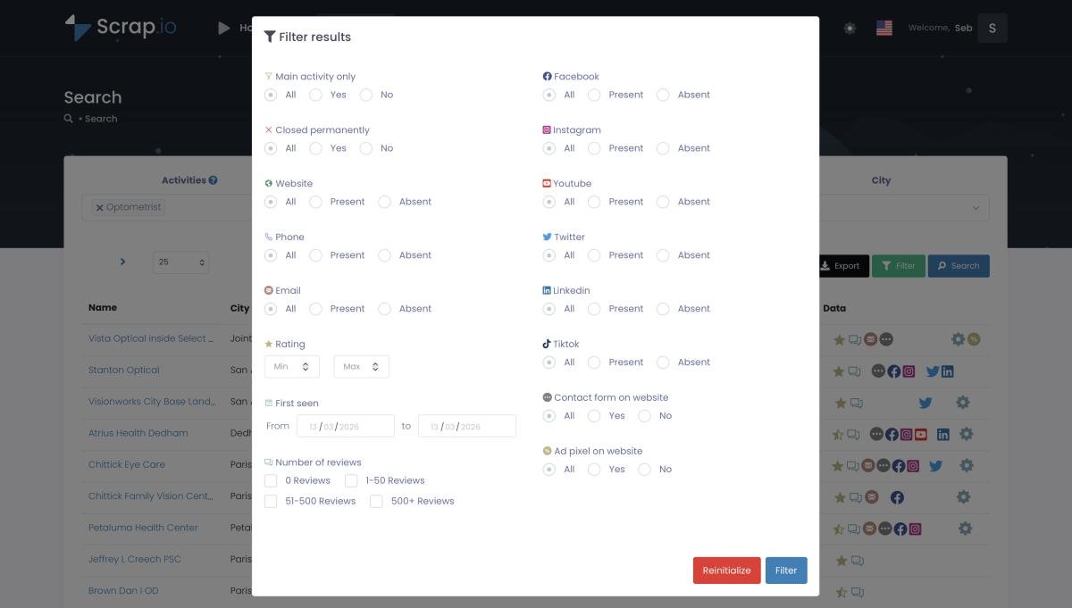
Now here's what gets interesting. What if you could tap into that database — not one business at a time, but thousands at once? That's what Scrap.io does. Pick a category (plumber, real estate agency, restaurant — there are 4,000+ categories). Pick a location. Set filters — only businesses with email addresses, or only ones rated 4 stars and above, or only ones without a website. Hit search. Get a clean CSV file.
Video: Scrap.io — How to Get Started?
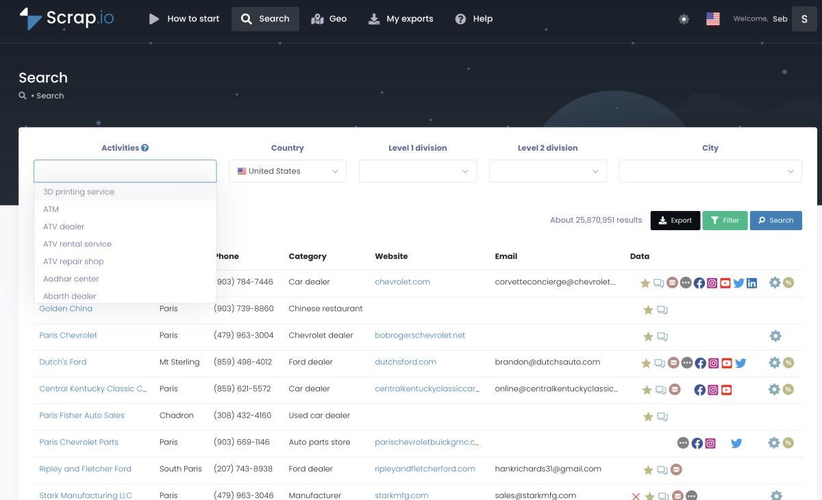
I ran "roofing contractors in Texas" last month. 2,400+ results. Emails, phones, websites, star ratings, social profiles. Took maybe 90 seconds. Collecting that manually? I'd still be at it.
And because the filters are applied before extraction, you don't burn credits on junk. No email on file? Filter it out before you pay. That's the whole trick. If you want the full walkthrough, we've got a complete email extraction tutorial and a deeper dive into generating Google Maps leads at scale. And for the people wondering about the legal side — read the legal framework around Google Maps scraping before you start.
Google Maps indexes 225 million+ businesses across 195 countries and 4,000+ categories — which makes it a goldmine for B2B prospecting. Scrap.io lets you extract and filter this data (by email, category, rating, location) in real time, before you spend a credit. Free trial, 100 leads included.
Who Uses Google Earth? Real Professional Use Cases
Google Earth isn't competing for your daily commute. Its users are a different crowd entirely.
City of Los Angeles — urban planning. LA's development teams use Google Earth Pro to compare satellite images from 2000, 2010, and 2020. They can literally watch neighborhoods expand, see which corridors got developed, track where parks disappeared under concrete. You can't do any of that on Google Maps.
Global Forest Watch — environmental monitoring. Built on top of Google Earth Engine, this platform tracks deforestation across entire continents in near-real-time. Researchers use it to monitor forest loss in the Amazon, Congo Basin, Southeast Asia. The data processing required would be flat-out impossible on any other consumer tool.
Educators. This one's underappreciated. Teachers take students on virtual field trips — the Grand Canyon, the Mariana Trench, the surface of Mars. (Yes, Mars. Earth Pro lets you explore it.) Try explaining tectonic plates to a room of fifteen-year-olds using a textbook versus flying them over the San Andreas Fault in 3D. Different experience entirely.
Real estate is another one. Zillow and Redfin are built on Google Maps APIs for property search and listings. But when an analyst needs to evaluate flood risk, terrain elevation, or what a neighborhood looked like before a housing development went up — they switch to Google Earth Pro. Maps gives you the business layer. Earth gives you the physical layer.
Google Earth Pro: Professional Features Worth Knowing
Here's a fun one. Google Earth Pro used to cost $399 a year. Google made it free in January 2015 (source: Google Earth blog). Four hundred bucks. Now it's zero. And most people still don't know it exists.
What do you actually get? Historical satellite imagery going back decades, with a timeline slider to scrub through it. Full KML/KMZ file import and export — that's the standard file format for geographic data. Advanced measurement tools (distance, area, circumference). High-resolution printing. Demographic overlays. You get all of this from the Google Earth Pro desktop download.
The web version of Earth is fine for casually spinning the globe around. But if you actually need to import GPS waypoints, layer custom datasets, measure land parcels, or build a presentation for a client — you need Pro. No way around it. (This is also, by the way, why "Google Earth vs Google Earth Pro" is a question people keep asking — short answer below in the FAQ.)
Oh, and you can explore the Moon, Mars, and the night sky. Is that useful for business? Not really. Is it cool? Absolutely.
Google Earth vs Google Maps for Developers
If you write code for a living, the consumer product comparison barely matters. What matters is the APIs.
Google Maps Platform gives you Places API, Directions API, Geocoding API, and a bunch more. This is what Uber, Zillow, DoorDash — basically every location-aware app — runs on. The complete Google Maps API guide covers the whole ecosystem, but the short version: you get programmatic access to 225M+ businesses, routing, geocoding, and distance calculations. The catch? Pricing. We're talking $32-40 per 1,000 requests on some endpoints. Our API pricing calculator shows when scraping becomes the cheaper option — and that threshold comes faster than most developers expect.
Google Earth Engine is something else entirely. It's a platform for planetary-scale geospatial analysis — satellite imagery processing, climate modeling, land cover classification. The audience is researchers and environmental scientists, not app developers. Think Python notebooks crunching terabytes of Landsat archives. Not restaurant finders.
These two don't really compete. Maps API = business applications. Earth Engine = scientific research. Different data formats, too. GeoJSON on the Maps side, KML on the Earth side. And while we're clearing up confusion — Google My Maps vs Google Earth trips people up as well: My Maps is a lightweight Maps feature for drawing your own custom maps, not the 3D research tool. If your project involves Place IDs, Google IDs, or CIDs, you're in Maps territory. If it involves analyzing satellite images from the last forty years — Earth Engine. Simple as that. Oh, and for the advertising and local marketing crowd — that's all Maps API.
The Verdict: Which Tool Should You Use?
After spending way too many hours testing these two side by side, here's where I landed.
Use Google Maps when you need to:
- Get directions. Obvious, but worth stating.
- Find local businesses — reviews, hours, contact info, the works.
- Do B2B prospecting or extract business data at scale.
- Build apps with location features.
- Run local SEO or competitive analysis campaigns.
Use Google Earth when you need to:
- Access historical satellite imagery.
- Do geographic, environmental, or archaeological research.
- Build presentations with terrain data and 3D views.
- Work with KML files or measure land areas.
For probably 95% of people reading this? Maps. Maps handles it. The other 5% — urban planners, geographers, environmental scientists, teachers — they already know they need Earth. And honestly? There's no rule saying you can't use both. When to use Google Earth vs Google Maps isn't really an either/or question. They solve different problems, like a Swiss Army knife versus a microscope.
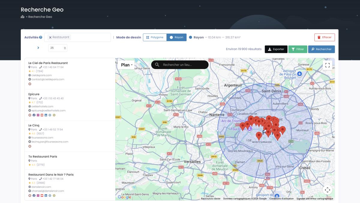
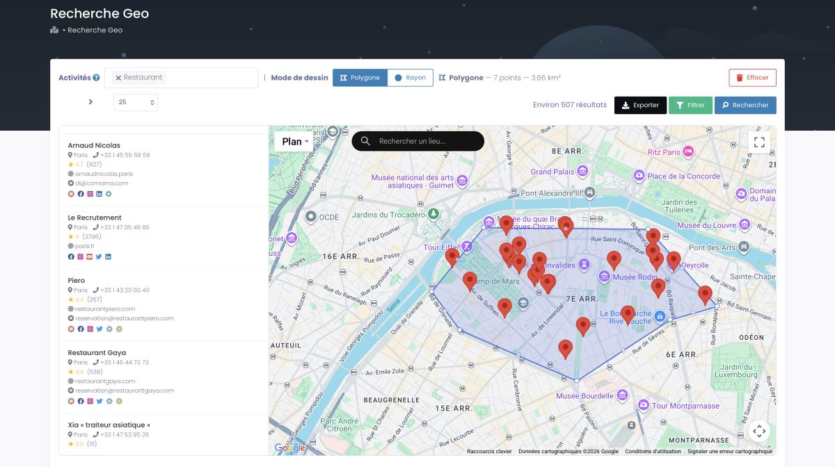
Need every dentist within a 15-mile radius? Or every coffee shop inside a custom-drawn zone? That's where Scrap.io turns Google Maps business data into something you can actually work with — no category required if you want a full economic map of a territory.
4,000+ Google Maps categories. 225 million+ businesses. 195 countries. Filtered by location, rating, email, social profiles — and exported fresh, in real time, at every run. Scrap.io turns this into an actionable lead list. Start with 100 free leads.
Frequently Asked Questions
Google Earth vs Google Earth Pro: what's the difference?
There's basically no difference in the data anymore. Google Earth Pro is the desktop version of Google Earth, free since 2015. Pro adds professional tools the web and mobile versions lack: a historical imagery timeline, KML/KMZ import and export, measurement tools, high-resolution printing, and demographic layers. Same globe, more power on desktop.
Which is more accurate, Google Maps or Google Earth?
Depends what kind of accuracy you mean. For business locations, hours, and contact info, Google Maps is far more current and complete. For geographic proportions and terrain, Google Earth wins — its 3D globe avoids the Mercator distortion that makes Maps inflate everything near the poles. Different kinds of accuracy, different tools.
What is Google Earth now called?
Still Google Earth. Nothing got renamed. There's Google Earth (web and mobile), Google Earth Pro (the free desktop app), and Google Earth Engine (the developer platform for satellite analysis). People sometimes confuse it with Google Maps' satellite view, but that's a separate feature living inside Maps.
Does Google Earth charge a fee?
No. Google Earth is completely free — web, mobile, and the Pro desktop version. Earth Pro used to cost $399 a year until Google made it free in 2015. And there's no paid tier for live satellite feeds either, because those don't exist for consumers. Everything Google Earth offers costs exactly zero.
Which is better, Google Maps or Google Earth?
Wrong question. They do completely different things. Maps is better for navigation, finding restaurants, checking reviews, doing anything practical in your daily life. Earth is better for research — satellite imagery, 3D terrain, historical analysis. Asking which is "better" is like asking if a wrench is better than a tape measure. Depends what you're building.
What's the difference between Google Maps and Google Earth?
Short version: Maps is 2D, built for navigation and business search. It indexes 225M+ businesses with reviews, hours, and contact details. Earth is 3D, built for geographic exploration and research. It has historical satellite imagery with a timeline, KML file support, and a desktop Pro application. Maps uses Mercator projection. Earth shows a globe. They share Street View data, but basically everything else is different.
Can I see my house in real time on Google Earth?
No. This is probably the most common misconception. Neither Google Earth nor Google Maps shows live satellite feeds — there's no "Google Earth live" mode. The images are static captures that can be months or even years old. Urban areas get refreshed more often than rural ones, but there's no published schedule. Real-time satellite imagery for specific locations just isn't available to regular consumers.
Is Google Earth Pro free?
Yep. Totally free since January 2015. Used to be $399/year — which is probably why people still assume you have to pay for it. Download it from earth.google.com/versions. You get everything: historical imagery, KML support, measurement tools, high-res printing, demographic layers. All of it. No catch.
What is Google Earth Pro used for?
Urban planning, environmental monitoring, real estate terrain analysis, education, archaeology. The two features that make Pro indispensable for professionals are the historical imagery timeline (you can watch a location change over decades) and KML file support (the standard for sharing geographic datasets). Think of regular Google Earth as the tourist version. Pro is the geographer's version.
When should I use Google Maps vs Google Earth for research?
Business research, competitive analysis, lead generation? Maps. It's got the listings, the reviews, the Google Maps business data vs Google Earth data — there's just no comparison on the commercial side. Tools like Scrap.io let you extract that data at scale. Geographic or environmental research? Earth. Earth Engine if you're doing anything with satellite data at volume.
Does Google Earth have better satellite imagery than Google Maps?
The actual imagery sources overlap — both use Landsat, Maxar, and other providers. But Earth lets you do way more with it. Historical timeline, multiple capture dates, higher zoom in some regions. Maps just gives you one snapshot with no context. For quick reference, Maps is fine. For anything deeper, Google Earth satellite vs Google Maps satellite isn't even a fair fight.
Are Google Maps and Google Earth the same app?
No. Separate products. Different teams. Different codebases. They share some data (Street View, for instance), but that's it. Google Earth started as Keyhole's EarthViewer 3D in 2001 and got acquired by Google in 2004. Maps was born inside Google in 2005 as a navigation tool. They've been separate the whole time and there's no indication Google plans to merge them.
Can you use Google Maps for lead generation?
This is actually one of the best-kept secrets in B2B. 225M+ businesses, each with contact details, reviews, categories — it's basically a massive lead database hiding in plain sight. Tools like Scrap.io let you extract and filter that data (by email, location, rating, category, you name it). It's way more efficient than LinkedIn scraping for local businesses. And you can check out the AI features now rolling into Google Maps — they're changing how this data surfaces.
225 million+ businesses. 195 countries. Filtered, exported, ready to use — fresh at every export. Try Scrap.io free for 7 days, 100 leads included. Try Scrap.io free — 100 leads included.
Generate a list of restaurant with Scrap.io
