By François | Scrap.io Team - Last updated: March 2026
Google Maps just turned 21. Nobody threw a party. We were too busy staring at our phones trying to figure out if the app was sending us down that weird back road again.
Here's a number that should stop you mid-scroll: in early 2026, the platform surpassed 2 billion active users, per SQ Magazine. Two billion. One in four humans on Earth, opening the same app, trusting the same blue line to get them where they need to go. And 67% of US smartphone owners pull it up at least once a week — which honestly sounds low to me.
What most people don't think about (and why would they?) is what happens between you typing "Whole Foods" and that route appearing. You're kicking off one of the most complex real-time computing operations any consumer has access to. Millions of possible paths. Traffic predictions for roads you won't reach for another 20 minutes. All crunched before you finish buckling your seatbelt.
So how does Google Maps route planning actually work under the hood? I spent a long time picking apart the algorithms, the data pipelines, the satellite infrastructure, the business data layer, and the massive Gemini-powered overhaul Google shipped in March 2026. Here's everything worth knowing.
Video: Google Maps: How Does it Work? — Scrap.io
[Image placeholder: Google Maps 2026 key statistics infographic — 2B+ users, 200M businesses, 170B Street View images, 220 countries, 4,000 categories]
Table of Contents
- Google Maps Route Planning: The Algorithm Revolution
- Real-Time Traffic Data: How Google Knows Before You Do
- The Magic Behind Google Maps Satellite Imagery
- Google Street View Technology: Getting Down to Earth
- Google Maps as a Business Search Engine
- Google Maps Data Extraction for Business Prospecting
- Google Maps Route Planning in 2026: What's New
- Privacy Concerns and Data Collection
- Frequently Asked Questions
Google Maps Route Planning: The Algorithm Revolution
That blue line on your screen? It looks simple. It's not. What you're actually seeing is the output of one of the most sophisticated route planning algorithms ever deployed at consumer scale. Millions of potential paths, evaluated and discarded in the time it takes to glance at your phone. The system that picks your morning commute route is processing more data per second than most companies handle in a day.
The Core: Dijkstra's Algorithm and Beyond
Google Maps route planning starts with Dijkstra's algorithm — a graph theory classic from 1956 that finds the shortest path between nodes in a network. But Google didn't stop there. (Nobody would use Maps if it took 30 seconds to calculate a route across Manhattan.)
The actual system runs a modified combo of Dijkstra's and A* (A-star) search. The difference matters. Dijkstra explores paths in every direction equally — thorough but slow. A* adds heuristics, essentially giving the algorithm a sense of direction. It prioritizes paths that are likely to lead somewhere useful instead of exhaustively checking dead ends.
On top of that, Google implemented Contraction Hierarchies — a preprocessing technique that pre-computes shortcuts in the road network. Think of it this way: you don't need to evaluate every side street between LA and San Francisco. The algorithm already knows the highway segments that matter. This is why your route loads in under a second even for cross-country trips. (For developers curious about the technical implementation, Google's Routes API documentation covers the Compute Routes and Route Matrix methods.)
Real-Time Data Layers
But algorithms alone aren't what make Google Maps route planning special. It's the data pouring in from every direction, every second.
Historical traffic patterns. Google has been hoarding traffic data for 20+ years now. The system knows your commute will take 22 minutes on a Sunday at 6 AM but 58 minutes on a Tuesday at 5:30 PM. This baseline powers every single route calculation.
Machine learning predictions. Planning a trip for tomorrow morning? Google's ML models analyze historical patterns, weather forecasts, local events, and even school schedules to predict what traffic will look like when you actually drive. According to Loopex Digital's analysis of Google Maps data, ETA predictions are accurate for 97%+ of trips. Ninety-seven percent. That's better than most weather forecasts.
Dynamic rerouting. This is the one that genuinely impresses me. Mid-drive, conditions change — an accident, sudden construction, whatever. The algorithm doesn't just recalculate from your current position. It factors in your current speed, direction, nearby alternatives, and predicted conditions on those alternatives. Seamless is the wrong word. (That's an AI word. Let's say: it works, and you barely notice.)
In March 2026, Google's Gemini-powered AI overhaul took this further — but we'll get to that later in the article.
[Image placeholder: Flowchart diagram showing how Google Maps route planning algorithm processes data in real-time]
How Google Maps Route Planning Compares to Alternatives
Google Maps isn't the only route planner out there. But it is the one with the most data — and in routing, data wins.
| Feature | Google Maps | Waze | Apple Maps | RouteXL |
|---|---|---|---|---|
| Real-time traffic | ✅ Crowdsourced + ML | ✅ Strong crowdsourced | ✅ Limited data pool | ❌ No real-time |
| Multi-stop optimization | Up to 10 stops | Up to 12 stops | Up to 15 stops | 20+ stops (paid) |
| ETA accuracy | 97%+ | ~95% | ~93% | N/A |
| Offline routing | ✅ Basic | ❌ | ✅ Basic | ❌ |
| Business data | 200M+ businesses | Limited | Growing | None |
| AI features (2026) | ✅ Gemini / Ask Maps | ❌ | ✅ Apple Intelligence | ❌ |
| Free to use | ✅ | ✅ | ✅ | Freemium |
Waze (which Google acquired in 2013 for $1.3 billion — yes, Google owns both) excels at police and hazard alerts. Its crowdsourcing model is more gamified, which means more active user reports. But for route optimization and business search? Google Maps wins by a mile.
Apple Maps has improved dramatically since its disastrous 2012 launch (Tim Cook had to publicly apologize — that bad), but it still trails in data volume. Fewer users means less crowdsourced traffic info, which means less accurate ETAs. It's fine for basic A-to-B navigation. Don't expect it to outsmart Google on a complex commute.
RouteXL and Route4Me target a different audience entirely — delivery drivers and field service teams who need 20, 50, or 100+ stops optimized. Google Maps' google maps multiple stops limit of 10 waypoints won't cut it for a courier with 40 packages. These tools exist because Google Maps wasn't built for delivery route optimization at scale — it was built for consumers getting to work.
For a deeper dive, check out our full Google Maps vs Apple Maps vs Waze comparison.
Real-Time Traffic Data: How Google Knows Before You Do
Clever algorithms are one thing. But Google Maps route planning doesn't run on math alone. It runs on data — a frankly absurd volume of it, updated every second, from sources most people never think about.
You Are the Data
This is the part that weirds people out once they really think about it. Every time you open Google Maps with location services on, your phone becomes a traffic sensor. Your speed, your position, your direction — all anonymized, all beamed back to Google. Multiply that by a couple billion users and you start to understand how Google knows about the accident on I-95 before the news does. A million phones suddenly decelerating on the same stretch of highway? That's congestion, and Google saw it in real-time.
According to Loopex Digital, users spend an average of 152 minutes per month on the app. Two and a half hours of passive data collection per user, times 2 billion+ users. I'll let you do the math on that one.
Data Fusion: Not Just Phones
Google Maps route planning doesn't rely on a single source. It's a mashup:
| Source Type | Description | Example |
|---|---|---|
| GPS / Android devices | Largest source — real-time speed and position from billions of phones | Devices decelerating on I-405 signals congestion |
| Municipal traffic systems | Government-operated traffic monitoring infrastructure | Traffic light timing data from the LA DOT |
| Road sensors | Physical sensors embedded in roadways by government agencies | Loop detectors counting vehicles on the Bay Bridge |
| Satellite imagery | Overhead analysis for construction zones and closures | New highway interchange detected via satellite |
| Crowdsourced reports | User-submitted incidents (also from Waze) | Accident reported by 15 users on the M25 |
Real-time traffic coverage hits 99% of urban areas in North America, per SQ Magazine. That number drops in rural areas, obviously — fewer phones, fewer sensors. But in any city of decent size, Google knows what's happening on your road right now.
The Routing Engine's Decision Process
When you request a route, Google's "routing engine" has to weigh all of this at once. Current speed on each road segment — not the speed limit, the actual speed people are doing right now. Predicted changes during the time it'll take you to get there. Road restrictions you've never heard of — weight limits, vehicle type bans, one-way streets that your GPS voice always announces two seconds too late. Even turn difficulty. (Left turns across traffic are statistically slower than right turns. The algorithm knows this.)
Then there are your preferences. Avoid tolls? Sure, but that might add 25 minutes. Prefer highways? Fine, but there's an accident on the merge ramp. The engine juggles all of it and spits out a route that's usually accurate to within a few minutes.
Not always, though. Construction zones sometimes fool it. Rural roads with sparse data remain a blind spot. But for any city or suburb where lots of people drive? Nothing else comes close.
And it keeps learning. Every route you take — and every one you abandon halfway through — becomes training data. Every time you follow an alternative suggestion and arrive faster, that reinforces the model. Every time you ignore it and hit gridlock, same thing. Two decades of this feedback loop across billions of users. The system doesn't just know traffic patterns in general. It knows your city's patterns at a granularity no human traffic engineer could match.
The Magic Behind Google Maps Satellite Imagery
[Image placeholder: Google Maps satellite view versus default map view comparison]
Open Google Maps right now. You've got two views. The cartoon-like default map — clean, color-coded, abstract. And the satellite view — actual photographs taken from space. Real buildings, real parking lots, that weird brown patch in your neighbor's yard.
This satellite layer is what makes accurate route planning possible in the first place. Can't navigate roads you can't map, and you can't map roads you can't see.
Here's something most people miss: zoom into any satellite image and check the bottom-right corner. You'll see attribution text — Terrametrics, NASA, Landsat, Copernicus, Airbus. Google doesn't own the vast majority of these images. They license them. From government agencies. From commercial satellite companies. And yes, from Airbus — the airplane manufacturer — which captures high-resolution aerial imagery from its own fleet.
The truly hard engineering problem isn't taking the photos. It's stitching them together. You've got imagery from a dozen providers, captured on different days, in different weather, with different cameras and exposure settings. Some patches are from last month. Others could be two years old. Google's algorithms have to blend all of that — color-matching, removing clouds, normalizing shadows — into something that looks like a single, continuous overhead photograph of the entire planet.
Pull that off and you've got the foundation for every route ever calculated. Fail, and your route planning system is building on quicksand.
Google Street View Technology: Getting Down to Earth
OK, that's the overhead view covered. Now let's talk about what's happening at ground level.
Street View has been around since 2007. The core technology is photogrammetry — basically, extracting 3D spatial data from 2D images. Google achieves this by strapping 360° cameras, lidar sensors, and GPS systems to the roofs of cars, then driving them down every accessible road on Earth. You've probably seen one. They're not exactly subtle.
The 2026 numbers are absurd. Over 170 billion panoramic images across 87 countries, covering 16 million+ miles of road (Wiser Review). To put that in context — 16 million miles is about 640 trips around the equator.
And when the car can't reach? Google sends people with backpacks. Or on bikes. Or snowmobiles. They've used camels in Abu Dhabi's Liwa Desert and divers for underwater shots of the Great Barrier Reef. Seriously. There's even footage from the International Space Station. The ambition is total planetary coverage, and they're weirdly close to achieving it.
One caveat most people don't realize: Street View images aren't live. Most are 1 to 3 years old, some older. That storefront you see might have been demolished last year. Google refreshes busy urban areas more often, but a random suburb could wait years between camera passes. Worth keeping in mind if you're using it to scope out a route before driving it.
Why Street View Matters for Route Planning
Street View isn't just virtual tourism. It feeds directly into route planning accuracy:
- Verifying road conditions and lane configurations that satellite images can't show clearly
- Identifying navigation landmarks for better turn-by-turn directions ("turn right after the red brick building")
- Detecting road closures and construction not yet reported by other sources
- Improving GPS accuracy in urban canyons where satellite signals bounce off skyscrapers
Google Maps as a Business Search Engine
People talk about Google Maps as a navigation tool. That undersells it massively. For a huge chunk of searches, Google Maps functions as a full-blown business search engine — and an incredibly good one.
Think about what happens when you type "plumber" into Maps. You don't get a route. You get a ranked list of plumbers near your exact location, with star ratings, review counts, photos of their work, business hours, phone numbers, and one-tap directions. That's more information in a single search result than most dedicated business directories provide. Now multiply that by 200 million businesses listed across 4,000 categories. Google announced in March 2026 that the platform now covers 300 million places total, fueled by contributions from 500 million users.
The data integrity effort is massive too. Google blocked 170 million+ policy-violating reviews in 2023 alone (Loopex Digital). Fake reviews are a constant arms race, and Google is pouring resources into fighting them.
How Business Data Feeds Route Planning
This massive directory isn't separate from navigation — it's deeply integrated into Google Maps route planning:
- Destination accuracy: precise coordinates for 200M+ businesses mean your route ends at the right door, not the parking lot across the street
- Real-time hours: the algorithm considers whether your destination will actually be open when you arrive
- Popular times: Google can suggest optimal departure times to avoid crowds at your destination
- Accessibility info: wheelchair access, parking availability, and other factors that affect route planning for specific users
If you're a business owner, your Google Maps listing directly affects how customers find and navigate to you. A bare-bones listing with no photos, no reviews, and incorrect hours? That's costing you foot traffic. Our guide on how to improve your Google Maps ranking covers the tactical side. And if you want to understand the paid advertising layer on top, our Google Maps advertising guide breaks down what it costs and whether it's worth it.
For businesses interested in tapping into Google Maps' 200M+ business listings for lead generation, platforms like Scrap.io let you extract and filter this data — with a free trial and 100 leads to test. If email outreach is your thing, our guide on how to find email addresses from Google Maps walks through the process step by step.
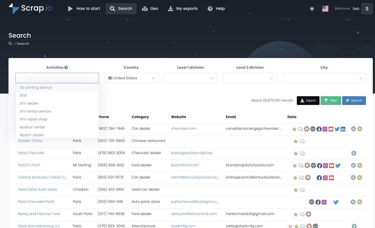
Google Maps Data Extraction for Business Prospecting
So we've established that Google Maps sits on top of a 200 million+ business database. Cool. Now the obvious question: can you actually use that data for something beyond finding a decent Thai restaurant?
Yeah. You can.
Scrap.io has been doing exactly this since 2021. The platform indexes the same 200 million+ establishments that live on Google Maps and lets you pull business data out of it — names, phone numbers, emails, websites, social profiles, reviews, categories — across 195 countries. The whole process is two clicks. No coding. No API keys.
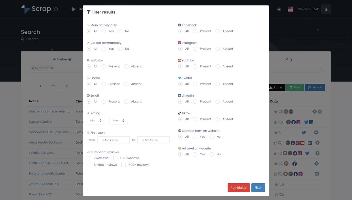
You pick a business category and a location. The platform returns your prospecting list, filterable by dozens of criteria (has email? has website? rating above 4.0?). Export to CSV or Excel. Done.
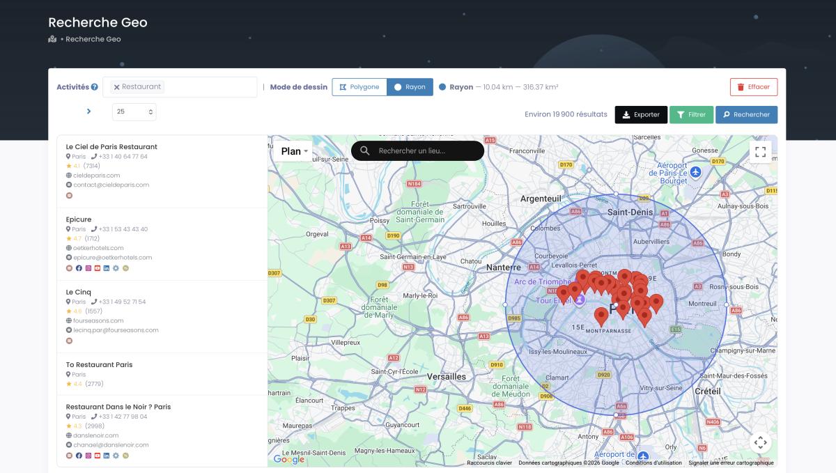
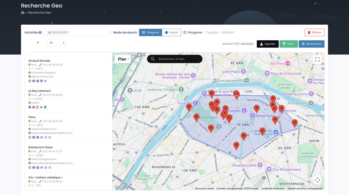
Need to target a specific geographic zone? Scrap.io offers both radius-based and polygon-based geosearch — draw your exact coverage area on the map and extract every business inside it. A 12-person roofing company in Nashville can pull every homeowner association and property management firm within a 30-mile radius. A SaaS startup can map every marketing agency in London with fewer than 50 reviews. The specificity is what makes it useful — not just bulk data, but targeted bulk data.
Pricing starts at €49/month for city-level searches, scaling to €499/month for country-wide extraction.
Companies like DHL already use Google Maps data for route optimization, cutting fuel costs by 15% across their fleet through real-time location intelligence. If you're looking to use this same business database for prospecting, Scrap.io provides access to all 4,000 Google Maps categories across 195 countries. Start with 100 free leads.
For the technical side of data extraction, we have guides on Google Maps scraping and API usage and the complete Google Maps API guide. And if you're watching costs, one transport company (RST Software) switched from Google Maps Platform to OpenStreetMap and went from $50,000/year to $2,400/year — a case we cover in our Google Maps API pricing analysis.
Google Maps Route Planning in 2026: What's New
March 2026 was a big month for Google Maps. The company unveiled a major redesign powered by Gemini AI, and it touches nearly every aspect of the product.
Ask Maps: Conversational Search
Remember typing "Italian restaurant open now near me with outdoor seating" and getting garbage results? Those days are ending. Ask Maps lets you just... ask. "Where should I take my parents for dinner? They love seafood, we're near the waterfront, and my dad has a bad knee so no stairs." Gemini processes the nuance, cross-references 300 million+ places, and returns suggestions that actually make sense.
Does it work perfectly everywhere? No. Not yet. When we tested similar Google Maps AI features in 2025, stuff that worked great in New York was basically useless in most European cities. Google says the March 2026 rollout closes that gap significantly. I'll believe it when I test it in a midsize French town.
Immersive Navigation
This one's genuinely impressive. Instead of the flat blue navigation line you've stared at for years, Immersive Navigation renders a full 3D photorealistic view of the streets around you as you drive. Buildings with actual textures. Traffic lights. Lane markings. Pedestrian crossings. All rendered in real-time using a combination of Street View imagery, aerial photography, and Gemini AI processing.
Is it gimmicky? A little. Is it useful? Actually, yes — especially in complex intersections where the traditional overhead view doesn't make it obvious which lane you need. For someone navigating an unfamiliar city, seeing a photorealistic preview of the next turn is genuinely helpful. Think of it as the difference between reading a map and having someone show you a photo of the intersection.
Eco-Friendly Routes
Google now shows fuel-efficient route alternatives by default. Not just a "green leaf" icon — actual estimated fuel savings and carbon reduction numbers for each alternative. About 30% of users actively engage with multimodal trip planning features that combine driving, transit, walking, and cycling in a single journey. That's a significant chunk of 2 billion users making greener choices because the algorithm nudged them.
Google Maps Walking Route Planner and Cycling
The walking route planner got a quiet but meaningful upgrade too. Street-level detail now includes sidewalk availability, pedestrian crossing locations, and elevation changes — useful if you're pushing a stroller or using a wheelchair. Cycling routes factor in bike lane infrastructure, road surface quality, and hill grades more accurately than before. Not game-changing for most people. But for the specific users who need it, the improvement is night and day.
What This Means for Route Optimization
For delivery companies and field teams, these updates matter. Better AI means better google maps route optimization — more accurate ETAs, smarter rerouting, and fewer wasted miles. For consumers, it means the gap between Google Maps and every competitor just got wider.
For businesses looking to use Google Maps advertising alongside these new features, the AI-powered search changes how customers discover local businesses.
Privacy Concerns and Data Collection
Two billion users tracked in real-time. Movement patterns archived. Daily routines profiled. Let's not pretend this isn't worth talking about.
What Google Maps Route Planning Collects
Every single navigation session generates a data trail. Where you started. Where you went. What route you took. How long you stopped at that coffee shop. Which businesses you searched for along the way. Your driving speed, your preferred departure times, the neighborhoods you pass through most often. Individually, each data point is mundane. Collectively? It's a comprehensive portrait of your daily life that most people never agreed to create.
The Regulatory Landscape
In 2024 and 2025, Google made significant changes to how Location History works. Users now have more granular controls, and location data is stored on-device by default rather than in Google's cloud. The EU's GDPR pushed many of these changes — Google faced multiple fines for opaque data collection practices.
But the regulatory landscape remains fragmented. In the US, there's no federal equivalent to GDPR. Some states have their own privacy laws (California's CCPA, Virginia's VCDPA), others have nothing. Google operates the same product globally but under wildly different legal constraints depending on where you live.
And then there are the gray zones. In France, the government uses Google Maps satellite data to identify undeclared swimming pools and garden sheds for tax purposes. (Not a joke — this has been documented since 2022.) Government agencies in multiple countries have requested location data for investigations. Google publishes a Transparency Report showing these requests, but the volume keeps growing year over year.
Here's a question nobody has a satisfying answer for: if Google can blur sensitive government facilities on satellite view for security reasons, why can't an individual homeowner request the same for their property? The asymmetry is hard to justify.
The AI Factor
As Google integrates more AI into Maps — Gemini reading your queries, learning your preferences, predicting where you'll go — the privacy implications multiply. The March 2026 AI overhaul makes Google Maps smarter. It also makes it hungrier for data. Ask Maps needs to understand your preferences to give good recommendations. Immersive Navigation needs to know exactly where you are at all times to render the 3D view. Every new feature adds another data point.
For most users, the trade-off is worth it. You get free, world-class navigation. Google gets your movement data. But "worth it" and "fully informed" are different things, and most people have never read Google's privacy policy. (Have you?)
For businesses working with Google Maps data, understanding the legal framework matters. Our article on whether scraping Google Maps is legal covers the key regulations.
Frequently Asked Questions
How does the Google Maps route planning algorithm work?
Short version: a mashup of Dijkstra's algorithm and A* search, turbocharged with Contraction Hierarchies so the math doesn't take forever. The system pulls in live traffic data from billions of phones, layering on 20+ years of historical patterns, current road conditions, and whatever preferences you've set (no tolls, no highways, etc.). It evaluates millions of possible routes in milliseconds. The factors it weighs include real-time road speed, predicted slowdowns during your trip, how tricky specific turns are, and any restrictions your car might not meet. All of that happens before your screen even finishes loading.
What makes Google Maps route planning so accurate?
Scale. That's it. Well, it's more nuanced than that, but scale is the foundation. GPS signals from 2 billion+ devices, traffic management systems from cities and municipalities, physical road sensors, satellite imagery, plus crowdsourced incident reports. All of that feeds into ML models trained on twenty years of driving data. The result is 97%+ ETA accuracy for most trips. Your weather app wishes it were that good.
How does Google Maps collect real-time traffic data?
Primarily through crowdsourcing. Every Android phone (and every iPhone running Google Maps) with location services enabled sends anonymous speed and position data to Google's servers. This gets combined with data from Waze users, municipal traffic systems, road sensors, and satellite analysis. Coverage reaches 99% of urban areas in North America.
Does Google Maps route planning work offline?
Partially. You can download maps for specific regions and get basic turn-by-turn directions without internet. But real-time traffic updates, dynamic rerouting, and live ETAs require a connection. Offline mode uses stored map data — think of it as a static GPS from 2005 rather than the full Google Maps experience.
How often does Google Maps update its route planning algorithms?
Constantly. Machine learning models retrain on new traffic data regularly, minor improvements ship daily, and major algorithm updates roll out several times per year. The March 2026 Gemini integration was the biggest single update in years.
Can Google Maps route planning avoid tolls and highways?
Yes. In route settings, you can exclude tolls, highways, and ferries. The algorithm recalculates within your constraints — though "most efficient toll-free route" sometimes means "30 minutes longer through residential streets." Trade-offs.
[Image placeholder: Google Maps route planning with multiple stops/waypoints example screenshot]
How does Google Maps route planning handle multiple stops?
Google Maps supports up to 10 waypoints (stops) per route. The system can optimize the order for efficiency, or you can set a fixed sequence manually. It's fine for running errands or a short delivery route. For 20+ stops, you'll need dedicated tools like RouteXL or Route4Me.
Pro tip from Reddit: Google Maps can technically handle longer routes if you manually construct the URL with extra waypoints. Not officially supported, but it works. (The r/GoogleMaps community has been doing this since at least 2024.)
Can Google Maps do route planning?
Yes — and it's one of the primary functions. You can plan routes with turn-by-turn navigation, add multiple stops, choose between driving/walking/cycling/transit, compare route alternatives, and share planned routes with others. For a free google maps trip planner, it's hard to beat.
Can I plan a route in Google Maps and save it for later?
Sort of. On mobile, you can search for a route and pin the directions. On desktop, you can share a route link or send it to your phone. But Google Maps doesn't have a built-in "saved routes" feature the way some dedicated route planner apps do. Workaround: save the route as a link in Google Keep or your notes app.
What data does Google Maps route planning collect about my travels?
Everything you'd expect, and then some. Starting locations, destinations, route preferences, timing, stops, search history, and driving patterns. Google uses this to improve traffic predictions for everyone. You can manage and delete this data through your Google Account > Location History settings. Since 2024, location data is stored on-device by default in most regions.
Conclusion
Twenty-one years. From a janky mapping tool barely anyone used to the navigation backbone for a quarter of humanity. That's the trajectory of Google Maps route planning.
The tech stack is bonkers when you think about it. Dijkstra's algorithm from 1956, paired with neural networks trained on two decades of traffic data, fed by 2 billion phones acting as real-time sensors, cross-referenced with 170 billion Street View images, and now supercharged by Gemini AI that can hold a conversation about where to eat dinner. Each layer makes the next one smarter. It's compounding.
March 2026's overhaul — Immersive Navigation, Ask Maps, better eco-routing — just widened the gap between Google and everyone else trying to compete in mapping. Apple Maps is fine. Waze is great for speed traps. But nobody else has the data flywheel.
The uncomfortable flip side? One company now has detailed movement data on 2 billion people. Where they go, when, how often, and which businesses they visit along the way. The privacy trade-off is real, and it's getting bigger with every new AI feature that requires more personal context to work properly.
What's next? If the current trajectory holds, expect AR navigation overlays through your phone camera within a couple years. Expect Maps to become the default interface for autonomous vehicles. And expect the business data layer — already 200 million strong — to keep expanding into smaller markets and smaller towns.
For now? It's still the best way to get from A to B. And for businesses, it's the richest database of potential customers ever assembled. Two hundred million businesses. Four thousand categories. 195 countries.
Ready to turn Google Maps into your lead generation engine? Try Scrap.io free — get 100 verified business leads instantly.
Ready to generate leads from Google Maps?
Try Scrap.io for free for 7 days.