By Scrap.io Team · Last updated: July 2026 · Estimated reading time: 18 min
Last month I helped a guy who runs a 40-truck delivery fleet in Indiana. He had a spreadsheet with 14,000 retail locations. No GPS coordinates. Just street addresses — and half of them were missing the ZIP code. He'd spent three days copying lat/lng from Google Maps by hand. Got through maybe 200 before he called me and said, word for word, "there has to be a less stupid way to do this."
There is.
I've been testing coordinate extraction methods for years now — some worked, most didn't, and one of them cost a client $600 in API fees before he realized he was doing it wrong. So here's what I know in 2026: there are three ways to scrape Google Maps coordinates, and the one people try first is almost always the worst. I'll walk you through all three so you can skip my mistakes.
Want the shortcut? Scrap.io handles this in a few clicks. We'll get to that in Method 3. And if the legal side worries you (it should, at least a little), we wrote a whole guide on Google Maps scraping legality.
Video: How to Scrape Google Maps Coordinates?
Table of Contents
- Why Extract Coordinates From Google Maps?
- Understanding Google Maps Coordinate Systems
- Method 1: Address-Based Extraction (Octoparse/Manual)
- Method 2: Place ID + Google Geocoding API
- Method 3: Data Enrichment — The Optimal Solution
- Comparing All Methods — Which One Should You Choose?
- Using the Scrap.io API for Automated Coordinate Extraction
- Real-World Applications of Coordinate Extraction
- Legal Considerations for Scraping Google Maps Coordinates
- Frequently Asked Questions
- Conclusion — Choose the Right Method for Your Scale
Why Extract Coordinates From Google Maps?
Money. That's the honest answer.
The geocoding API market alone was worth $1.45 billion in 2024, growing at 13.2% per year (Growth Market Reports). Geofencing? $3.22 billion in 2025, on track for $11.85 billion by 2034 (Fortune Business Insights). Google Maps brings in over $3 billion a year just from API access fees (OrbilonTech, 2026). These aren't niche numbers. Latitude and longitude coordinates from Google Maps power entire industries now.
I see it constantly with our users. A 30-person trucking company needs GPS pins for every stop on a 12-state route. A real estate developer in Atlanta wants every coffee shop, school, and bus stop within a mile of a potential site — with coordinates, not just names. A direct mail agency won't send 5,000 postcards to fitness studios unless they can map them precisely by ZIP code first. A SaaS company building a store locator for a franchise with 800 locations needs clean lat/lng to render map pins correctly — and the franchise corporate office sent them an Excel file where half the addresses are missing suite numbers.
72% of retailers ran geofencing promotions in 2025 (SNS Insider). Every single one of those campaigns started with coordinates. Not addresses. Not city names. Actual latitude/longitude pairs, because that's what ad platforms need to draw a targeting circle on a map.
Oh, and 80% of "near me" searches happen on mobile (Search Engine Journal). When someone types "plumber near me" on their phone, Google is comparing their GPS coordinates against the coordinates of every plumber listing within range. That's all coordinates under the hood. So if you touch location data professionally — even a little — you're going to need Google Maps coordinates at some point. The question is just how you get them without wasting a week or burning through $500 in API fees you didn't budget for.
Understanding Google Maps Coordinate Systems
Latitude: north-south, -90° to +90°. Longitude: east-west, -180° to +180°. Google Maps uses decimal degrees — 37.7749, -122.4194 for San Francisco — not the degrees-minutes-seconds format your geography teacher loved. Google's official reference page has the details if you need them.
Here's the trick that saves you time.
Open any listing on Google Maps. Look at the URL in your browser. See that @37.7749,-122.4194,15z part? That's latitude, comma, longitude, comma, zoom level. Coordinates are sitting right there in every single Google Maps URL. Most people have no idea.
Pulling them out takes two lines of code. Python:
import re

url = "https://www.google.com/maps/place/.../@37.7749,-122.4194,15z/..."

match = re.search(r'@(-?\d+\.\d+),(-?\d+\.\d+)', url)

lat, lng = match.group(1), match.group(2)
JavaScript version:
const url = "https://www.google.com/maps/place/.../@37.7749,-122.4194,15z/...";

const match = url.match(/@(-?\d+\.\d+),(-?\d+\.\d+)/);

const [lat, lng] = [match[1], match[2]];
Great for one URL. Terrible for ten thousand. That's where things start getting complicated — and where people start making expensive mistakes. I get emails about this every week: "I wrote a script to loop through URLs and it worked for the first 50, then Google blocked me." Yeah. They do that.
If you need to go the other direction (coordinates → address), that's called reverse geocoding and we've got a separate guide on it.
Method 1: Address-Based Extraction (Octoparse / Manual)
Everyone starts here. Makes sense — you've got addresses in a spreadsheet, you want GPS coordinates, Google Maps converts addresses to map pins. Just automate that, right?
Right. Except it doesn't really work.
The setup with Octoparse is fine. Point it to google.com/maps, find the search box, tell it to type your address and hit Enter, wait for the page, then grab the URL. The @ in the URL gives you your lat/lng, same regex as above. I've done this setup probably fifty times for people. Takes about 20 minutes to configure.
Then you run it on real data. And everything falls apart.
Type "312 Oak Street, Birmingham" and sometimes you land on a business detail page. Perfect — one address, one set of coordinates, done. But type something slightly less specific and Google gives you a list. Three locations. Five locations. Which one did you mean? Your scraper doesn't know. It grabs whatever coordinates Google put in the URL for the list view, and those coordinates are for the center of the results, not your target business.
I ran a test. 50 addresses from a real CRM database. Results:
31 gave me a clean detail page with accurate coordinates. 12 returned multiple results — coordinates were wrong or at least unreliable. 7 just... failed. Timeout. CAPTCHA. Page didn't load. That's 62% accuracy. And the other 38% still need human eyeballs, which kills the whole point of automation.
It gets worse with volume. Google starts throwing CAPTCHAs after a few dozen searches in a row. You can add delays in Octoparse — 5 seconds, 10 seconds between each query — but then extracting 500 addresses becomes an overnight project. For 5,000 addresses? Forget it.
| Pros | Cons |
|---|---|
| Free (manual or Octoparse free tier) | Accuracy drops with ambiguous addresses |
| No API key or billing needed | Can't handle true bulk extraction |
| Works for small, precise address lists | Breaks when Google changes UI elements |
| No coding required with Octoparse | Rate limiting kills throughput |
| — | Requires manual QA for multi-result addresses |
Bottom line: if you've got 30 super-specific addresses with full street, city, state, and ZIP — sure, go for it. Concatenate them in Excel first (use =A1&", "&B1&", "&C1&" "&D1 if you're lazy like me). For anything bigger, you're going to hate yourself by hour two.
I've seen people try to "fix" this method by running Octoparse overnight, then manually reviewing every failed result in the morning. It works — technically. But you're basically paying yourself $8/hour to do what a better tool does instantly. Unless your time is genuinely worth nothing (and if you're reading a guide about scraping Google Maps coordinates, it probably isn't), move on to Method 2 or skip straight to Method 3.
Method 2: Place ID + Google Geocoding API
Place IDs are Google's internal identifier for locations. Each one looks like ChIJgUbEo8cfqokR5lP9_Wh_DaM — completely unreadable, but it points to exactly one place. No ambiguity. No "did you mean this Springfield or that Springfield." One ID, one business, one set of coordinates. That's the selling point.
Sounds airtight on paper. Then you look at what real people actually run into. There's a thread on r/Entrepreneur asking for the best Google Maps scraping tool (140+ comments), and one line stuck with me: "I have built my own google maps scraper... but it is really expensive to run." That's the API method in a nutshell. It works. It also quietly drains your budget.
The Google Geocoding API turns Place IDs into lat/lng pairs. Here's the code:
import requests


place_id = "ChIJgUbEo8cfqokR5lP9_Wh_DaM"

api_key = "YOUR_API_KEY"

url = f"https://maps.googleapis.com/maps/api/geocode/json?place_id={place_id}&key={api_key}"


response = requests.get(url)

data = response.json()

lat = data['results'][0]['geometry']['location']['lat']

lng = data['results'][0]['geometry']['location']['lng']
Works beautifully. Status 200, clean JSON response, exact coordinates. I've got zero complaints about the accuracy. If every API worked this reliably I'd be out of a job.
The complaints are about everything else.
The Cost Problem
Google charges $5 per 1,000 Geocoding API requests once you burn through their free 10,000-per-month tier (Google Maps Platform Pricing). Sounds cheap. It isn't, at scale:
| Volume | Free Tier Covers? | Cost After Free Tier |
|---|---|---|
| 100 extractions | ✅ Yes | $0 |
| 1,000 extractions | ✅ Yes | $0 |
| 10,000 extractions | ✅ Barely | $0 |
| 50,000 extractions | ❌ No | ~$200 |
| 100,000 extractions | ❌ No | ~$450 |
Our API pricing calculator shows exactly where the crossover point is between the API and scraping tools. Spoiler: it's lower than you'd think.
The Bigger Problem: Getting Place IDs
Nobody mentions this part in the tutorials. To use the Geocoding API you need Place IDs. But where do those come from? You can look them up one by one in Google's Place ID Finder tool. Great for 5 locations. Useless for 5,000.
Getting them programmatically? That requires the Places API. Which costs $32 to $40 per 1,000 results. So you're paying $35 per thousand to get the IDs, then another $5 per thousand to turn them into coordinates. You've now built a two-step pipeline where each step has its own API key, its own billing, its own rate limits, and its own failure modes. A developer friend of mine put it best: "It's like paying for the key, then paying for the lock, then finding out the door is behind another door."
If your CRM already stores Place IDs — or you pulled them from Google Maps URLs — this method is rock solid. The Geocoding API docs are actually well-written. (Which, coming from Google, is saying something.)
But if you're starting from zero? Method 2 solves half the problem and charges you twice. Our Place ID complete guide explains how Place IDs, CIDs, and Google IDs differ, and when each one matters.
Not a coder? You might prefer to scrape Google Maps without Python entirely.
Method 3: Data Enrichment — The Optimal Solution
So addresses are cheap but unreliable. Place IDs are reliable but expensive and hard to get. What if you could use something that's both easy to find AND uniquely identifies a business?
You can. Website URLs. Phone numbers. Email addresses. Domain names.
Think about it: a business website almost always belongs to one company. Joe's Plumbing in Tulsa has one website. That website maps to one Google Maps listing. One set of coordinates. A phone number on Google Maps connects to one location — same logic. Match those against Google Maps data and you get one business with coordinates attached. Same accuracy as Place IDs, none of the two-step-pipeline-from-hell.
This approach is called data enrichment. And it's what Scrap.io was built for.
Video: Scrap.io - How to Start?
What Makes Scrap.io Different
225 million businesses indexed across 195 countries. Real-time matching against Google Maps. You throw in a website URL, you get back the full profile — GPS coordinates, address, phone, emails, social media, reviews, the works. 45+ data fields per business, exported straight to CSV or Excel.
Here's the search interface where it all starts — pick your categories and location, and the count updates before you spend a single credit:
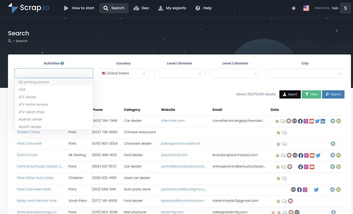
But here's what actually gets people excited (and what I think separates this from every other tool I've used):
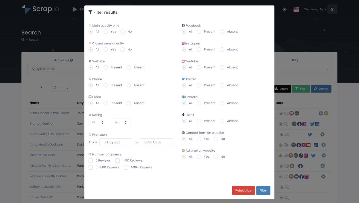
Filtering before extraction. This is the one nobody expects. You apply your filters — website present, email present, mobile number only, minimum review count — before credits get consumed. You're not paying to export junk you'll delete later. Only useful contacts count against your quota:
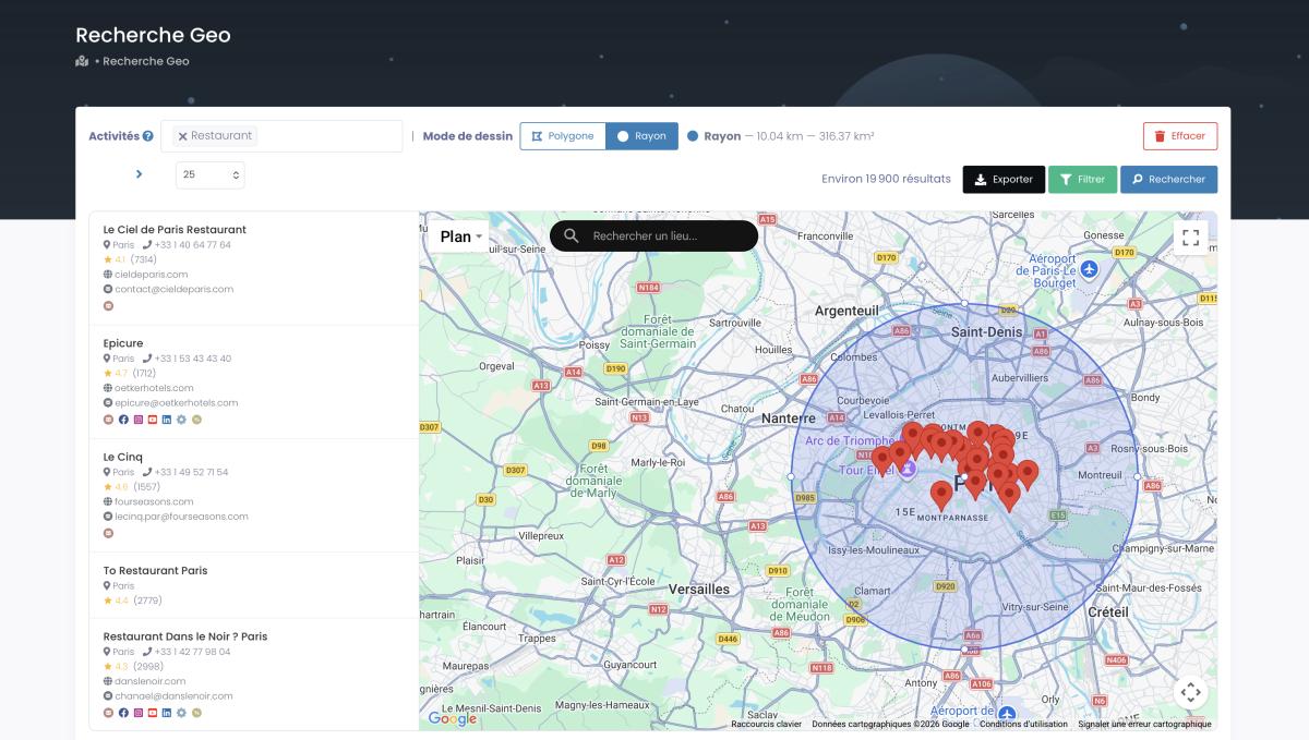
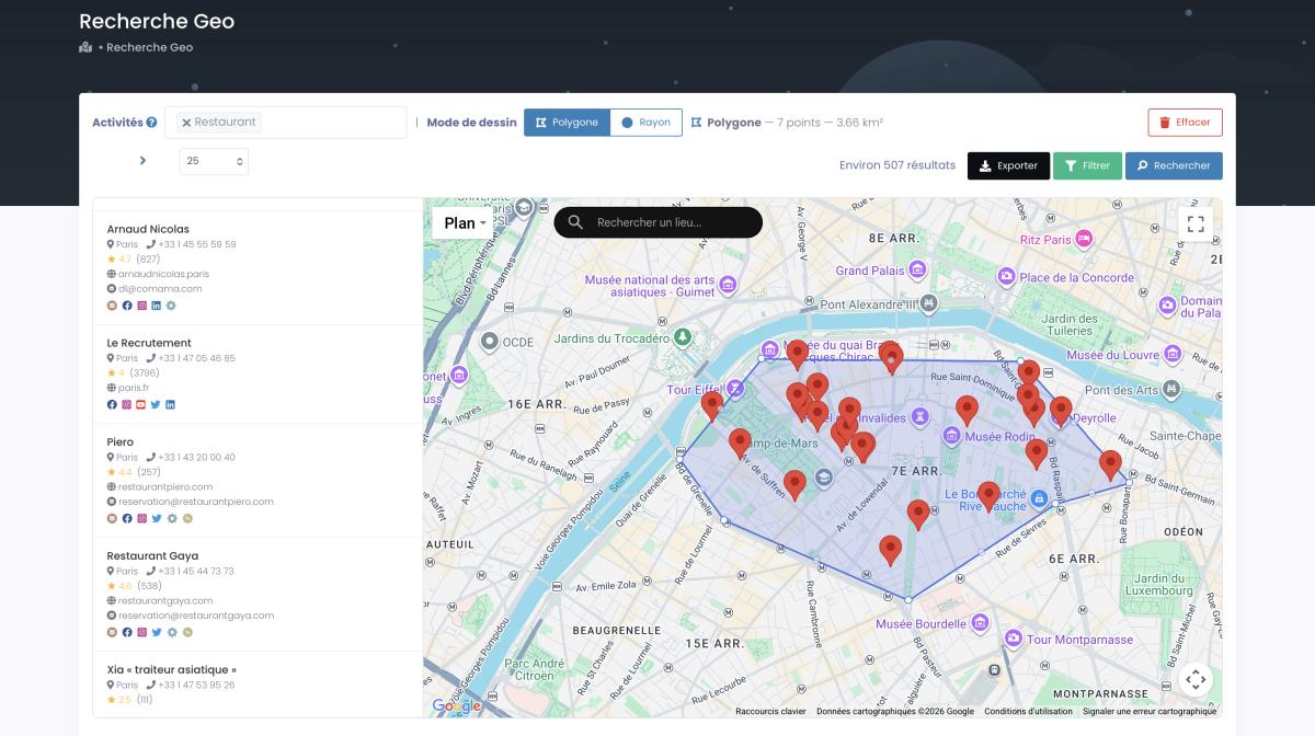
Geofencing by radius or polygon. You don't have to extract by "category + city" anymore. Drop a pin, draw a circle (up to 500 km on the top plan), and pull every business inside. Or trace an irregular polygon around an industrial park, a neighborhood, whatever boundary makes sense (up to 1,000,000 km² on the Company plan). The geofencing market sits at $3.22 billion in 2025 and is heading to $11.85 billion by 2034 — this isn't a gimmick. It's where the industry is going, and Scrap.io already does it.
Multi-category filtering. Restaurants AND bars AND cafés in one search. Not three separate exports you then merge in Excel at 11 PM. One search. Done.
GPS in every export. Latitude and longitude show up automatically in every file. You don't configure it, you don't toggle it. It's just there. Every time. This alone saves a whole step that used to require a separate geocoding process.
Here's what a typical Scrap.io export contains:
| Category | Fields Included |
|---|---|
| Location | Latitude, Longitude, Full Address, Street, City, State, ZIP, Country |
| Contact | Phone, Email, Website URL, Contact Page URL |
| Social Media | Facebook, Instagram, LinkedIn, TikTok, Twitter/X, YouTube |
| Google Maps | Place ID, CID, Google ID, Owner Name, Business Category |
| Reviews | Average Rating, Total Reviews, Rating Distribution (1-5 stars) |
| Business Info | Opening Hours, Price Range, Photos Count, Description |
| Website Data | Meta Title, Meta Description, Technologies, Ad Pixels |
People come for the coordinates. They stay for the 44 other columns. I've seen it over and over.
Scrap.io returns GPS coordinates for every business listing — plus geofencing by radius or polygon to target specific areas, and 45+ fields in every export. Try it free with 100 leads included — GPS in every export.
Want simpler options for small projects? Chrome extension scrapers work OK for a handful of listings — and our free Chrome extension shows emails and socials right on the Google Maps interface. Our complete Google Maps scraping guide covers every method from Python to no-code.
Using the Scrap.io API for Automated Coordinate Extraction
For anything recurring — nightly batch jobs, CRM enrichment, feeding data into a BI tool — you'll want the API. It's dead simple:
import requests

import json


url = "https://scrap.io/api/v2/gmaps/enrich"

params = {

    "url": "https://example-business.com",

    "per_page": 1

}

headers = {

    "Authorization": "Bearer YOUR_API_KEY"

}


response = requests.get(url, params=params, headers=headers)

data = response.json()

latitude = data[0]['location_latitude']

longitude = data[0]['location_longitude']
Pass a website URL, get back coordinates plus the entire business profile. Swap "url" for "phone" or "email" and it works the same way. Loop through a CSV of 10,000 URLs and you've got bulk coordinate extraction — no Geocoding API, no Place ID hunting, no billing surprises. Full reference lives at docs.scrap.io.
The API also works with domain names, which is nice if you've scraped a list of company websites and stripped them down to root domains. Each identifier maps to a unique Google Maps listing, so accuracy stays high.
One thing I always tell people: start with the no-code interface first. Make sure the data looks right, check a few coordinates in Google Maps to verify, then move to the API for automation. I've seen too many developers wire up a pipeline before confirming the output matches what they need. Takes 10 minutes to check. Saves hours of debugging later.
If you want to get fancy, Scrap.io's geofencing endpoints let you extract coordinates by geographic area directly through the API — define a center point and radius, or pass polygon coordinates, and the API returns every business inside that boundary. That's basically a location intelligence pipeline in a single GET request.
Comparing All Methods — Which One Should You Choose?
I promised a comparison. Here it is:
| Criteria | Address-Based | Place ID + API | Data Enrichment (Scrap.io) |
|---|---|---|---|
| Accuracy | ⚠️ Medium — ambiguous addresses | ✅ High — one ID, one location | ✅ High — unique business match |
| Scalability | ❌ Low — manual or fragile automation | ⚠️ Medium — API limits + costs | ✅ High — bulk extraction built-in |
| Cost (10K locations) | $0 (but hours of manual time) | ~$50 API fees | Scrap.io subscription |
| Technical skill needed | Medium (Octoparse, regex) | High (Python, API setup, billing) | Low (no-code interface) |
| Data points returned | Coordinates only | Coordinates only | Coordinates + 45+ fields |
| Geofencing support | ❌ | ❌ | ✅ Radius + Polygon |
I'll make it even simpler.
Under 50 locations, specific addresses, don't mind some manual cleanup? Method 1. Free. Slow. Good enough.
You're a developer, you already have Place IDs from somewhere, and you need fewer than 10K lookups? Method 2. Accurate. Annoying to set up but predictable once it's running.
Literally anything else? Method 3. Not even close. You get the coordinates, you get 45 other data fields, and you don't have to touch a terminal. That's why most of our users end up here.
Most of our users end up here. Skip the coding and the API bills — with Scrap.io you extract coordinates (plus 45 other fields) for thousands of businesses in a few clicks. Try it free with 100 leads.
Evaluating alternatives? Our OutScraper comparison goes into the details.
Real-World Applications of Coordinate Extraction
Theory is nice. Here's what people actually do with the coordinates they extract.
Fleet Management and Route Optimization
Fortune Business Insights says 70% of transport companies improved resource utilization after adopting geofencing. Makes sense — if your route optimization software has the exact GPS pin for every stop (not "somewhere near 4th and Main"), it can shave minutes off each delivery. Over 30 trucks and 200+ daily stops, those minutes compound fast. Three or four extra deliveries per driver per day isn't unusual once you swap out loose addresses for verified lat/lng coordinates.
The workflow: use Scrap.io's radius geofencing to pull every delivery point in a metro area, export to CSV, feed it into RouteXL or OptimoRoute or Google's Directions API. Optimized routes, same afternoon. You draw the radius straight on the map, like this:
Direct Mail Marketing
Botster.io documented a real campaign: direct mail targeting fitness centers in Birmingham, Alabama. The team extracted coordinates for every gym in specific ZIPs, mapped them, and built mailing zones from the actual locations — not from ZIP code approximations. ZIP boundaries are weird and messy. They don't follow streets or neighborhoods. Polygon geofencing in Scrap.io lets you draw the actual shape of the area you care about:
When each mailed piece costs $0.50 to $2.00, cutting 10% waste on a 5,000-piece campaign saves real money. That's $250 to $1,000 — from a five-minute geofence adjustment.
Real Estate Site Selection
Before a developer drops $8 million on a new mixed-use site in Atlanta, they want to know what's around it. Every restaurant, transit stop, school, grocery store, and competitor within a mile. All with GPS coordinates so they can map density, calculate walkability scores, compare against a second site across town.
I talked to a commercial real estate analyst last year who said his firm used to hire interns to manually catalog nearby businesses for each potential site. Two interns, three days, per site evaluation. Now they run a Scrap.io geofence extraction, download the file, and have every POI mapped in an hour. The coordinates go straight into their GIS software. The interns now do actual analysis instead of data entry — which, honestly, is a better use of everyone's time.
The broader geocoding and reverse geocoding market grew from $12.3 billion in 2022 and is headed toward $33.4 billion by 2030 (DataM Intelligence). Real estate and urban planning are a massive chunk of that.
Geomarketing Campaigns
Remember the 72% geofencing stat? Those retailers aren't guessing — they're pulling GPS coordinates for their stores, their competitors' stores, and high-traffic locations, then building ad zones around each one. A regional bank running a "new customer" promo can geofence every competitor branch location and trigger mobile ads when people walk nearby.
Video: GeoFencing: How to Find Leads Through Location?
The economics are wild. It works because 80% of "near me" searches are on mobile — every coordinate is a potential touchpoint. And when you combine that with Scrap.io's ability to extract not just coordinates but also review scores, opening hours, and website data for competitors... you can build campaigns that target specific competitor weaknesses by geography. "Their Yelp score is 3.2 in this ZIP code? Let's push our 4.7 rating to everyone within a mile." That's not theoretical — I've seen agencies build exactly this.
Our geomarketing guide goes deep on how to build these campaigns step by step.
Legal Considerations for Scraping Google Maps Coordinates
I'm not a lawyer. That said, I've had this conversation a hundred times and here's what I tell people.
Extracting publicly available business data from Google Maps — names, addresses, phone numbers, coordinates — is generally OK for legitimate business purposes. "Generally OK" is the key phrase there. There are limits.
Google's Terms of Service explicitly prohibit automated scraping of their platform. The "approved" method is using their APIs, which means rate limits and per-request fees. If you build a custom bot that hammers google.com/maps directly, expect blocks. Possibly a cease-and-desist letter.
Third-party tools like Scrap.io work differently. Scrap.io maintains its own index of 225+ million businesses — you're querying that index, not scraping Google in real-time. Big difference, legally and practically.
GDPR and CCPA. Business addresses and phone numbers are usually public data. A plumbing company with its address on Google Maps? Public. Sole proprietor with a home address listed as their business location? That's where it gets messy. If you're extracting anything related to EU businesses, assume GDPR applies and behave accordingly. The fines aren't hypothetical — ask any company that's received one. For US data, CCPA is more lenient on business information, but you still can't collect data about California residents without a legitimate purpose. Scrap.io is GDPR- and CCPA-compliant, works only with publicly available business data, and every field stays traceable to its source.
Rate limits. Even with legit API access, blasting thousands of requests per second gets you throttled or banned. Scrap.io handles the load balancing on their end so you don't have to worry about it. If you're building your own pipeline with the Geocoding API or custom scrapers, be respectful. Add delays. Handle 429 responses gracefully. Don't be the person who ruins it for everyone.
Full breakdown in our legal guide. Planning to email the businesses you find? Read the cold email compliance guide on CAN-SPAM, GDPR, and CASL first.
Frequently Asked Questions
How do I extract GPS coordinates from Google Maps in bulk?
Fastest way: use Scrap.io. Upload business websites, phone numbers, or emails — the platform returns GPS coordinates plus 45 other fields. No coding. The Scrap.io API does the same thing for automated workflows. The Google Geocoding API works too, but you'll need Place IDs and it gets expensive past 10,000 requests.
What's the difference between using addresses vs Place IDs for coordinate extraction?
Addresses can match multiple listings. Type "123 Main Street" and Google might return five results in five states. Bad coordinates. Place IDs point to exactly one location — always accurate. The catch: Place IDs are hard to get in bulk. Data enrichment via URLs or phone numbers gives you unique matches without that hassle.
Is there a free Google Maps coordinates extractor?
Google's Geocoding API gives you 10,000 free requests per month. You can also grab coordinates manually from the @lat,lng pattern in any Google Maps URL. For bigger volumes, Scrap.io's free trial includes 100 leads with full GPS data.
How to convert a Google Maps link to latitude and longitude?
Every Google Maps URL has coordinates baked in: @latitude,longitude,zoom. Copy it, run a regex like @(-?\d+\.\d+),(-?\d+\.\d+), done. Two lines of Python. Check the code snippet earlier in this guide under "Understanding Google Maps Coordinate Systems."
What is geofencing and how does it relate to coordinate extraction?
Geofencing means drawing a virtual boundary — circle or custom polygon — around a real-world area. Everything inside gets targeted. But you can't draw a geofence without GPS coordinates. Scrap.io combines both: set a geofence, extract all businesses inside, coordinates included.
Can I export Google Maps data to Excel with coordinates?
Yes. Scrap.io puts latitude and longitude in every CSV and Excel export. Search by category, location, or geofence — the downloaded file always includes GPS coordinates along with the business name, address, phone, email, reviews, and everything else.
Is it legal to scrape coordinates from Google Maps?
Public business data (including coordinates) is generally fair game for legitimate commercial use. Respect Google's ToS and local data laws (GDPR, CCPA). Using an indexed tool like Scrap.io instead of scraping Google directly is the safest route. Our legal guide has the full details.
What tools do I need for bulk coordinate extraction?
Depends on volume and skill level. Small batches: manual URL copying or Google Geocoding API. Mid-range with coding: Python + Geocoding API or Scrap.io API. Large-scale, no coding: Scrap.io's web interface. Other players include Apify, Outscraper, Botster, GmapsExtractor — most need more setup and return fewer data fields.
How accurate are coordinates extracted through different methods?
Place IDs: best accuracy, one ID per location. Scrap.io enrichment: equally accurate, because website URLs and phone numbers are unique identifiers. Address-based: worst, because ambiguous addresses match multiple listings. All methods pull from Google's own geocoding — accuracy differences come from how reliably you hit the right listing.
Can I automate coordinate extraction for ongoing projects?
Yes — both Scrap.io's API and Google's Geocoding API support automation. Feed in a list, get coordinates back, schedule it to run nightly or weekly. Our JavaScript API extraction guide covers building custom pipelines if that's your thing.
What's the Google Maps Geocoding API and when should I use it?
It converts addresses or Place IDs into lat/lng (and vice versa). Official Google product. $5 per 1,000 requests after the free tier. Requires an API key with billing. Use it when you have clean Place IDs and a manageable volume. Past 10K lookups or when you need richer data, Scrap.io is cheaper and gives you more. Setup help: API key guide. Full geocoding comparison: geocoding API guide.
How do I find email addresses alongside coordinates?
Scrap.io pulls both in the same export — emails and GPS coordinates, same file. If you specifically need to enrich existing data with emails, our finding emails on Google Maps guide covers several approaches.
What data fields does Scrap.io include besides coordinates?
Business name, full address, phone, website, email, social media (Facebook, Instagram, LinkedIn, TikTok, Twitter, YouTube), review count, average rating, rating breakdown, opening hours, categories, Place ID, CID, Google ID, owner name, price range, photo count, website meta info, technologies used, ad pixels detected — 45+ fields total.
Conclusion — Choose the Right Method for Your Scale
Addresses: free, unreliable, tops out at maybe 50 lookups before you start making errors nobody catches until it's too late. Good for tiny projects with ultra-specific addresses. I use it maybe once a year, and only when someone sends me like 20 addresses that already include ZIP codes.
Place ID + Geocoding API: precise, well-documented, but expensive to set up and run at volume. Best if you're a developer who already has Place IDs from somewhere. If you don't — you'll spend as much getting the IDs as converting them. I respect this method technically, but it's a solution designed for a different problem (geocoding known locations) being shoehorned into a use case it wasn't built for (bulk extraction from scratch).
Scrap.io: accurate, no-code, and you walk away with 45 data fields on top of coordinates. Geofencing by radius and polygon means you're not just scraping coordinates — you're targeting specific geographic areas. That's the difference between a spreadsheet of lat/lng values and actual business intelligence you can act on.
The geocoding market is growing at 13%+ a year. Geofencing is headed toward $11.85 billion by 2034. And the tools keep getting easier. What used to take a developer and a weekend now takes a few clicks and a CSV download.
Pick the method that matches your volume. Don't overcomplicate it. And if you're the Indiana fleet guy reading this — yes, you should've called me sooner.
Ready to extract Google Maps coordinates at scale? Start your free 7-day trial on Scrap.io and get 100 leads with GPS coordinates instantly.
Generate a list of restaurant with Scrap.io
