

Okay so here's the thing. Most people hear "geofencing" and think about that random notification they got from Starbucks when they walked past one. You know the deal. "Hey! Your latte is waiting!" or something like that.
But that's honestly just scratching the surface.
The market hit $1.8 billion in 2023 and is projected to reach $4.3 billion by 2028 according to MarketsandMarkets. That's not growing because of coffee coupons. There's something way bigger happening. Businesses are using location-based targeting for competitive intelligence, trade area analysis, and lead generation at a scale most people don't realize.
And with 6.8 billion smartphone users worldwide (Statista, 2024) making spatial data more accessible than ever, we're at this interesting point where virtual perimeters aren't just for big retail chains with massive tech budgets anymore. Pretty much any business can use them. Even yours.
So let's break this down. What exactly is geofencing? How does it work? And more importantly – how can you use it to actually grow your business instead of just annoying people with push notifications?
Understanding Geofencing Technology
What is Geofencing? The Basic Definition
Simple version. Geofencing is a virtual boundary you draw around a real-world geographic area. When a device – phone, tablet, GPS tracker, whatever – enters or exits that boundary, something happens. An action gets triggered.
Think of it like an invisible fence. Except instead of keeping your dog in the yard, it's detecting when people or devices cross a specific geographic line.
The technology behind this relies on a mix of GPS, WiFi, RFID, and cellular data to pinpoint locations. Your phone already does this constantly. Every time Google Maps knows you're near a restaurant, that's location intelligence at work.
But here's what nobody really explains well. This isn't one thing. It's a framework. The "fence" is just the trigger. What matters is what you DO with that trigger. Send an ad? Collect data? Track a fleet? Analyze a market? Completely different applications using the same core technology.
How Geofencing Works: The Technical Process
The whole thing works in four steps. Super simple when you break it down.
Step 1: Define your geographic boundary. You pick a location on a map and draw your zone. Could be a circle with a radius (like "everything within 10km of downtown Austin") or a custom polygon shape (like drawing around a specific neighborhood).
Step 2: Device detection. When a smartphone or GPS-enabled device enters your defined area, the system detects it. This happens through GPS satellites, WiFi triangulation, or cell tower data.
Step 3: Trigger activation. The system registers that a device crossed the boundary. This is the "fence event" – the moment something is supposed to happen.
Step 4: Action execution. The system responds. Maybe it sends a notification. Maybe it logs the event in a database. Maybe it adds a data point to your analytics dashboard. Depends entirely on what you set up.
The accuracy? GPS-based location tracking is accurate within 5-10 meters. That's close enough to tell the difference between someone standing in front of your store versus the one next door.
Types of Geofencing
Not all geofences are shaped the same. And the shape actually matters more than you'd think.
Radius-based boundaries are the most common. You pick a center point, set a distance, and the system creates a circular perimeter. "Show me everything within 25km of this location." Easy to set up. Works great for service businesses with a defined coverage area.
Polygon boundaries are where things get interesting. Instead of a circle, you draw a custom shape on the map. Maybe you want to target a specific neighborhood. Or a business district. Or a weird-shaped commercial zone that no circle could accurately cover. You draw it freehand and the system respects those exact boundaries.
Radius targeting gives you speed. Custom polygon boundaries give you precision. Both have their place depending on what you're trying to accomplish.
Geofencing Applications Across Industries
Geofencing Marketing & Advertising
This is the one everyone knows. 70% of marketers report using location-based marketing tactics according to Marketing Dive (2024). And for good reason – campaigns using virtual perimeters average 2-3x higher engagement rates than traditional digital ads (Mobile Marketer, 2024).
Retail stores send promotions when customers walk nearby. Event organizers target attendees at conferences. Some businesses even do competitor conquesting – setting up virtual perimeters around competitor locations and serving ads to people who visit them.
A restaurant sends a lunch special offer when someone walks within 200 meters. An auto dealer targets people leaving a competitor's lot. A gym runs ads around office buildings at 5 PM. You get the idea. Location-based advertising works because it reaches people at the exact moment geographic context makes the message relevant.
Business Intelligence & Data Collection
Now here's where this technology gets really powerful. And honestly? This is the part most articles completely skip.
53% of businesses now use location data for competitive intelligence according to Gartner (2024). That's not push notifications. That's serious market analysis.
Imagine you're a commercial real estate broker in Austin. A new mixed-use development zone just got approved. You need to know every single business already operating in that area. Manually searching Google Maps? That could take days. With geofence targeting on a data platform, you draw a polygon around the zone and extract everything in minutes.
Or say you're an HVAC company with five locations. You need prospects within a 25km radius of each office. That's your service area – your trade area analysis. Drawing five radius boundaries and pulling all the commercial businesses inside them gives you a precise, location-filtered prospecting list. No waste. No irrelevant leads from three states over.
This is real-time location data applied to business intelligence. Not consumer tracking. Not ad serving. Actual market research that drives decisions.
Fleet Management & Logistics
Quick mention here because it's relevant. Delivery companies and service fleets use location-based boundaries to track vehicles, optimize routes, and get alerts when drivers deviate from assigned areas. It's a huge industry. But it's not really our focus today.
Security & Safety Applications
Parents tracking kids. Pet owners with GPS collars. Companies monitoring equipment leaving authorized zones. All proximity-based applications. All legitimate. All worth noting.
But let's talk about what most businesses actually need.
Geofencing for Business Data & Lead Generation
Why Businesses Need Location-Based Data Filtering
Here's the problem nobody talks about. You need business contacts in a specific area. What are your options?
Option A: Buy a national database and filter by zip code. You'll pay for thousands of contacts you don't need, and half of them are probably outdated anyway.
Option B: Manually search Google Maps for businesses, one by one, copying and pasting into a spreadsheet. I watched someone do this once. Took him an entire afternoon to get 87 contacts. Eighty-seven. His coffee went cold twice.
Option C: Use area-based filtering software to draw your exact service area and extract every business inside it automatically. Fresh data. Complete contact info. Done in minutes.
The math is kind of obvious here.
How Scrap.io's Geofencing Works
This is where things get really interesting. Scrap.io built location-based zone targeting directly into their Google Maps data extraction platform. Two methods. Both dead simple.
Method 1: Radius selection. Pick a point on the map. Set your distance in kilometers or miles. The system draws a circle and identifies every business inside it. Want all restaurants within 10km of your location? Done. Two clicks.
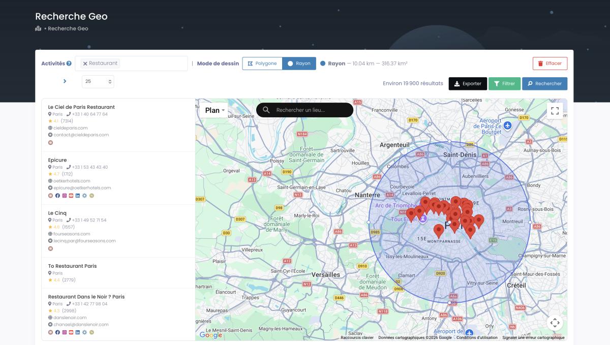
Method 2: Polygon selection. Draw a custom shape directly on the map. Follow the outline of a specific neighborhood, a commercial district, or whatever irregular area you need. The system extracts all businesses within your custom boundary.
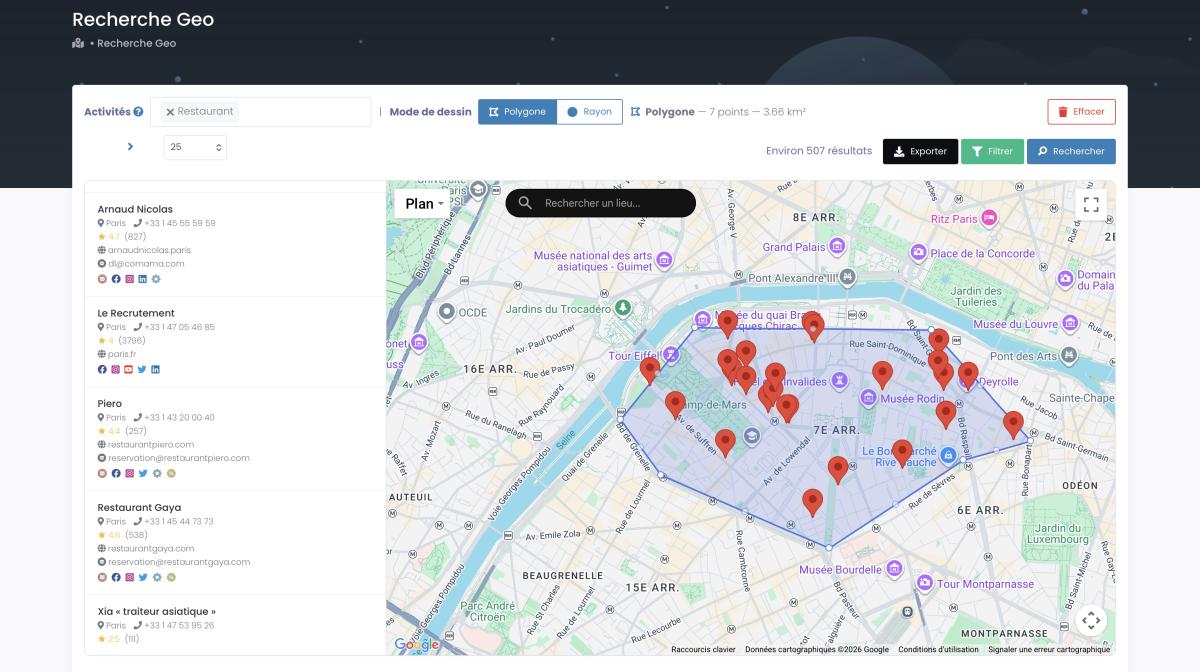
No code. No technical knowledge required. If you can use Google Maps – and I'm pretty sure you can – you can use this.
And because it's pulling real-time data directly from Google Maps and business websites, you're not getting contacts from six months ago. You're getting what exists right now. When agencies update their listings or change their info, you get that fresh data immediately.
The filtering goes deeper too. Want clinics with bad Google reviews who might need reputation management help? Filter for it. Businesses with no social media presence? Found them. Companies with email addresses but no website? Right there. It's zone targeting meets smart filtering in one platform.
Real-World Business Use Cases
Let me give you some concrete examples because abstract concepts don't pay the bills.
Commercial real estate broker. A CRE broker in Austin used custom polygon boundaries to extract all businesses in a new mixed-use development zone. In 15 minutes, she had a complete prospecting list of 237 businesses with contact data, helping her identify tenants before competitors even knew where to look.
Regional HVAC company. They used 25km radius boundaries around each of their 5 locations to build service area prospect lists. Result: 3,200 qualified local business leads updated quarterly. No more paying for national databases full of contacts three time zones away.
Franchise development team. A national franchise used geographic zone analysis to evaluate competitor density in potential expansion markets. By drawing polygons around target neighborhoods, they identified underserved areas with high business activity – the sweet spots for new locations.
Marketing agencies building hyper-local prospecting lists for their clients. Instead of buying bulk data by state or zip code, they generate targeted lead lists for specific neighborhoods and business districts. Way more precise. Way less waste.
Retail site selection. Understanding what businesses already operate in a catchment area before investing. Drawing a polygon around a potential store location reveals the full business mix – competitors, complementary services, foot traffic generators.
Benefits of Geofencing for Business Intelligence
Why does this matter? Let me run through the practical benefits.
Precision targeting. You only pay for data you actually need. No more buying an entire state database when you operate in three cities. Draw your zones. Extract your leads. Done.
Real-time data. Google Maps contains 200+ million business listings worldwide. When those listings update, the data you extract reflects those changes. Always current. Always valid.
Time efficiency. What used to take days of manual research now takes minutes. Draw a radius or polygon, apply your filters, export your file. We're talking about thousands of contacts in the time it takes to make coffee.
Cost optimization. At roughly 10,000 fresh contacts for about $50, zone-based extraction costs a fraction of traditional business data providers charging 10-50 cents per contact. The math works even if you're a solo consultant.
Competitive intelligence. Draw a virtual perimeter around your competitor's territory. See exactly who their potential clients are. Understand the business density in their area. That's information you can actually act on.
Scalability. Start with a single neighborhood polygon. Scale to entire cities. Then regions. Then entire countries with two clicks. The technology works at every level.
Geofencing Privacy & Compliance
Is Geofencing Legal?
Fair question. And an important one. 79% of consumers are concerned about location tracking according to Pew Research (2023). That's a lot of people worried about privacy.
But here's the critical distinction. There's a massive difference between tracking individual consumers as they walk around town – which raises legitimate privacy concerns – and accessing publicly available business data that companies themselves posted online.
Using virtual boundaries for business data collection falls squarely in the second category. When a restaurant puts their address, phone number, and email on Google Maps, that information is public. Extracting it using location-based tools doesn't involve tracking any individual. It's collecting business information that was made public intentionally.
Scrap.io's approach is straightforward. Public business listings only. Google Maps data that companies published themselves. 100% GDPR compliant. No sketchy gray areas. No questionable data sources.
Privacy Best Practices
Even with public data, being ethical matters. Transparency about how you use business contact information. Compliance with CAN-SPAM for email outreach. Respecting unsubscribe requests immediately. Following proper cold email compliance guidelines isn't just legal requirement – it's good business.
If you're working internationally, GDPR applies to European contacts. The rules are clear and Scrap.io is built to comply with both US and EU data protection regulations.
Getting Started with Geofencing
Geofencing vs Geotargeting: Quick Clarification
People mix these up constantly so let me clear it up. Geofencing creates a virtual boundary that triggers actions when crossed. Geotargeting delivers content based on a user's location without that boundary-based trigger. Related concepts. Different mechanisms.
For business data extraction, this approach is what you want. It gives you a defined area with clear boundaries. Everything inside gets captured. Everything outside doesn't.
Choosing the Right Approach
When should you use radius versus polygon?
Radius works best when your business has a clear service range. "We cover everything within 30km." Simple. Effective. Perfect for service companies, delivery businesses, and anyone with a circular coverage area.
Polygon works best when your target area is irregularly shaped. Specific neighborhoods. Commercial districts. Development zones. Anywhere a circle would either include too much irrelevant area or exclude important zones.
83% of US retail chains use some form of location-based perimeter targeting according to RetailDive (2024). They're not all using the same approach. Match your method to your geography.
Try Geofencing with Scrap.io
Here's the deal. Scrap.io offers a 7-day free trial with 50 searches and 100 export credits. Enough to test the feature in your actual market and see the quality of data you get back.
No technical knowledge required. No code. No API setup unless you want it. Just draw your area on a map and start extracting business data.
Plans start at €49/month with 10,000 export credits. The pricing page has full details, but honestly? For most businesses, the basic plan covers more leads than you can follow up on in a month anyway.
Your first 100 leads are free of charge. So there's literally no reason not to try it.
Frequently Asked Questions
What is geofencing used for?
It's used for location-based marketing, business intelligence, fleet tracking, and security applications. Businesses use virtual boundaries to target customers or collect data within specific geographic zones. The B2B applications – trade area analysis, competitive intelligence, lead generation from specific areas – are where the real growth is happening.
How accurate is geofencing?
GPS-based location boundaries are accurate within 5-10 meters. Accuracy depends on the technology used (GPS, WiFi, cellular) and environmental factors like building density and weather. For business data extraction, this level of accuracy is more than enough to define meaningful geographic zones.
What's the difference between geofencing and geotargeting?
The first creates a virtual boundary that triggers actions when crossed. The second delivers content based on user's current or past location without boundary-based triggers. Think of one as drawing a line on a map. The other is more about knowing where someone is or has been.
Can I use geofencing for B2B lead generation?
Absolutely. And you should. This approach is excellent for B2B because it lets you identify and extract business contact data within specific geographic zones. Instead of buying broad national databases, you target exactly the areas that matter to your business. Tools like Scrap.io make this accessible without any technical skills.
Is geofencing expensive?
Cost varies by solution. For consumer marketing applications (push notifications, mobile ads), costs can run into thousands monthly. For B2B data collection, Scrap.io offers location-based filtering starting at €49/month with 10,000 export credits, making it accessible even for small businesses and solo consultants.
Do I need technical skills to set up geofencing?
Not with modern tools. Scrap.io's zone targeting feature uses a visual map interface – draw your area with radius or polygon tools and start extracting data. No coding. No API knowledge. If you can use Google Maps, you can do this.
Time to Draw Your First Geofence
Look. This market is growing from $1.8 billion to $4.3 billion for a reason. Businesses are figuring out that location-based targeting isn't just about sending coupons to people near coffee shops. It's about understanding markets, finding prospects, and making smarter decisions based on geographic reality.
65% of businesses now prefer custom polygon boundaries for trade area analysis over simple radius (industry reports, 2024). They're getting more precise. More targeted. More effective.
Whether you're a franchise team scouting expansion markets, a service company building local prospect lists, or a real estate pro analyzing business density in a development zone – geographic zone targeting gives you the data precision that generic databases simply can't match.
Start your free trial with Scrap.io and draw your first geofence today. 7 days. 50 searches. 100 export credits.
And always remember – your first 100 leads are 100% free.
Now stop reading guides and go find some prospects. They're literally sitting on a map waiting for you to draw a circle around them.
Generate a list of businesses in your area with Scrap.io