A meal-delivery startup once asked us a question that sounded almost too simple: "Where do our best customers actually live?" Not their demographics. Not their lifetime value. Just where. They mapped it, redrew their delivery zones around the answer, and doubled their delivery efficiency in 30 days. One map. That was the whole intervention.
Here's the uncomfortable part. Roughly 80% of all business data has a location component buried inside it — every sale, every delivery, every signup happens somewhere — and most companies never touch that layer. They've got the dashboards. They've got the KPIs. They just left the most valuable column unread.
That column is location intelligence. And in 2026, ignoring it is a choice your competitors are quietly hoping you'll keep making.
Video: Google Maps API: What Data can be Collected?
- What is Location Intelligence? (Definition & Core Concepts)
- Why Location Intelligence Matters in 2026 ($28.7B Market)
- Location Intelligence vs Traditional Analytics: Key Differences
- Top 8 Real-World Use Cases Across Industries
- Getting Started: Essential Data Types & Sources
- Location Intelligence Tools: From Free to Enterprise
- Building Your First Location Intelligence Strategy
- Future Trends: AI, IoT & Real-Time Analytics
- Legal & Compliance: Using Location Data Responsibly
- Frequently Asked Questions
- Take Action
What is Location Intelligence? (Definition & Core Concepts)
So, what is location intelligence in plain language? It's the practice of turning geographic data into business decisions. You take the data you already have — sales, customers, shipments — and you add the "where," then you look for the patterns that only show up once geography is in the picture.
Both Wikipedia's entry on the topic and Esri's definition land in roughly the same place: location intelligence is the capability that derives meaningful insight from the geographic relationships within data. IBM frames it as the layer that lets organizations visualize and act on spatial context. Fancy phrasing for a simple idea — where changes everything.
Think about it like this. Regular analytics tells you that you sold a thousand units last month. Location intelligence tells you that 600 of them sold within two miles of three specific neighborhoods, and that a fourth, nearly identical neighborhood across town bought almost nothing. Same product. Same price. Wildly different outcome. The difference was where, and you'd never have seen it in a spreadsheet.
This is sometimes called spatial intelligence, spatial analytics, or location data analytics. The labels move around. The core stays the same: business data, plus geographic context, processed into something you can act on. Not magic. Closer to glasses you didn't know you needed.
The Building Blocks of Spatial Intelligence
Every location intelligence setup rests on three layers, and skipping any one of them breaks the whole thing.
First, data collection. GPS signals from roughly 5.6 billion smartphone users worldwide in 2026, sensor feeds, satellite imagery, and — the workhorse most people underrate — public business listings on map platforms. Every Google Maps update is a tiny packet of spatial truth.
Second, processing and analysis. This is where software hunts for the patterns a human would take a decade to notice. Why does your Austin location outperform Dallas by 40%? The processing layer is what answers that.
Third, visualization and action. Numbers don't move anyone. A heat map that screams "open your next store HERE" moves people. And here's the kicker — the volume of raw spatial input keeps exploding, with more than 30 billion connected IoT devices feeding the pipe in 2026. The bottleneck was never data. It's still the willingness to use it.
Why Location Intelligence Matters in 2026 ($28.7B Market)
Let's talk money, because the market itself is the loudest argument. If you've been hunting for a credible location intelligence market size 2026 figure, here it is: the global location intelligence market crossed $28.7 billion in 2026, according to market research on the sector (Business Research Insights, 2026). And it's not plateauing — projections put it between $74.8 billion and $109.5 billion by 2035, a compound annual growth rate in the 11.4%–16.0% range depending on whose model you trust (Precedence Research / Global Growth Insights, 2026).
Quadruple, in under a decade. That's the trajectory.
Extracting structured business data — the raw material of location intelligence — directly from Google Maps.
Why are companies pouring capital into this? Because the returns are showing up on the balance sheet. 75% of retail companies now say location intelligence is critical to revenue growth (Forbes, 2024). In real estate, organizations using location intelligence report 23% higher returns (Precisely, 2025). And the mindset shift among serious investors is stark: 67% of institutional investors view location intelligence platforms as essential, up from just 31% in 2020 (Deloitte Real Estate Outlook, 2025).
That last number is the one I'd tattoo on a boardroom wall. In six years, "essential" doubled.
Why Companies Are Investing Heavily
Take DHL Supply Chain. They run real-time location analytics across their fleet to optimize routing, and they've cut fuel costs by 15% (DHL / IBM case studies). When you operate thousands of vehicles, 15% isn't a rounding error — it's a line item that funds entire departments.
Retail tells the same story from a different angle. Starbucks doesn't drop stores on hunches. They run foot-traffic models, demographic overlays, competitor proximity, even commute patterns through spatial analysis — and they credit that discipline with roughly a 20% reduction in bad-location risk (Esri / public reporting). Everyone else is playing checkers. They're three moves deep on a board nobody else can see.
Over on Quora, one practitioner summed up the field neatly: "Location intelligence is a form of data intelligence that relies on insights gained from visualization and decryption of location data." Decryption is the right word. The signal is sitting there in plain sight, encrypted only by the fact that nobody bothered to map it.
Where It's Growing Fastest
Geographically, North America holds about 32% of the global market, with the United States as the single largest contributor. Software accounts for roughly 60% of all revenue in the category — meaning businesses aren't just buying data, they're buying the tools to interpret it.
California, Texas, and New York lead adoption, no surprise there. But the interesting movement is in the second tier — Florida, Georgia, and metros like Seattle, Austin, and Denver are closing the gap fast. The playbook leaks downward. What an enterprise piloted in 2023, a regional chain is operationalizing in 2026.
Location Intelligence vs Traditional Analytics: Key Differences
You've got dashboards, KPIs, and weekly reports. So why are your forecasts still landing 40% off? Fair question. The honest answer is that traditional analytics and location intelligence answer fundamentally different questions, and most teams only ever ask half of them.
Traditional business intelligence is brilliant at what and when. How much did we sell? When did churn spike? Which campaign converted? Genuinely useful. But it treats every variable as if it floated in space, disconnected from the physical world where your business actually happens.
The location intelligence vs business intelligence distinction isn't a rivalry. It's a missing layer. Here's the comparison side by side:
| Dimension | Traditional Analytics (BI) | Location Intelligence |
|---|---|---|
| Core question | What happened? When? | Where? And why there? |
| Data shape | Rows, tables, time series | Maps, layers, geographic clusters |
| Typical output | Sales totals, retention rates | Site selection, territory planning, catchment areas |
| Blind spot | Ignores physical context | Needs BI data to be useful |
| Prediction accuracy | Baseline | Up to 40% more accurate |
Picture a coffee-shop chain that couldn't explain its erratic store performance. Traditional analytics gave them volumes, peak hours, top SKUs — all accurate, all useless for the actual problem. Add the location layer and the fog lifts: stores near gyms sold protein drinks at 7 a.m., stores near campuses tripled late-night orders. The "what" was always visible. The "why" lived in the "where."
That's the 40% gap, distilled. Businesses using location intelligence report up to 40% more accurate predictions than those relying on traditional analytics alone — because weather, competitors, accessibility, and local demographics all bend your numbers, and they're all functions of location. Traditional BI files them as separate variables. They were never separate. (For more on how spatial and tabular data complement each other, see this breakdown of Google Maps data extraction.)
Top 8 Real-World Use Cases Across Industries
When Cavender's Western Wear needed to triple their expansion pace in 2025, they didn't hire a small army of site scouts. They plugged in location intelligence and opened 27 new stores that year, vetting candidate sites roughly three times faster than their old process allowed (Precisely / Place Informatics). Same playbook, different vertical: TNT Fireworks used location intelligence to evaluate 10x more candidate sites and stand up 150+ locations in under six months (Place Informatics / Precisely). These aren't hypotheticals. These are location intelligence use cases — real location intelligence examples generating revenue right now, the kind you'll find scattered across the case studies of every serious vendor.
Retail: Site Selection & Customer Understanding
Retail is where location intelligence for business earns its keep most visibly — so much so that "location intelligence retail" is practically its own discipline now. Walmart evaluates trade areas, population shifts, competitor density, traffic flow, and even nearby construction before committing a single square foot. But the real story in 2026 is that small operators finally do a version of the same thing, which is where location intelligence for small business stops being a buzzword and starts being a budget line.
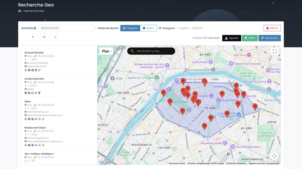
Drawing a custom polygon to extract every competing business inside a precise retail trade area.
Opening a gym? You can pull every fitness business in your city from Google Maps, read their review counts, scan their pricing signals, and find the underserved pocket. That used to require a consultant and a month. Now it's an afternoon.
Logistics: Route Optimization & Fleet Management
DHL's 15% fuel savings is the headline, but the discipline runs deeper. Amazon positions fulfillment centers based on predicted future demand, not just current orders. Uber's entire business is real-time location intelligence — matching supply and demand across a moving map, second by second, accounting for traffic, driver density, and surge prediction.
Fleet managers lean on location intelligence platforms to reroute on the fly, schedule maintenance by route stress, and benchmark driver behavior across road types. Boring? Maybe. Profitable? Absolutely.
Real Estate: Market Analysis & Investment
Real estate went from clipboard-and-intuition to spatial modeling almost overnight, and "location intelligence real estate" is now one of the fastest-growing slices of the whole category. A Seattle-based REIT used location intelligence to guide acquisitions and saw +34% appreciation over 18 months, versus an 11% market average (GrowthFactor.ai). Triple the market. That's not luck — that's reading the map before the crowd does.
Investors now score properties street by street: pricing trends, zoning, flood and crime exposure, foot traffic for commercial sites. The 67% of institutional investors who call this "essential" aren't being dramatic. They've watched the 33% who skipped it leave money on the table.
Marketing: Hyper-Targeted Campaigns
This is where it gets almost unfairly precise. Marketers have stopped targeting cities and started targeting blocks. A restaurant pushes soup promos to specific neighborhoods when the temperature drops. A retailer serves offers to people who frequent a competitor's location. That's location-based intelligence doing the quiet work — and it's why so many location intelligence companies, from specialists like CARTO to broad data players, now build their entire pitch around marketing teams. If you run B2B, the same logic powers geolocation data for B2B marketing — finding the right accounts in the right places, then reaching them before anyone else notices the cluster.
Insurance & Risk Assessment
Here's a use case the old version of this guide completely missed — and it's exploding. Insurers now use spatial data to price risk with surgical accuracy: proximity to flood plains, wildfire corridors, crime density, even the species of trees near a property (one carrier found homes near certain tree types suffered 30% more storm damage). Underwriting used to run on ZIP-code averages. Now it runs on coordinates. The result is fairer pricing for low-risk customers and far fewer surprises for the insurer. Risk, it turns out, has an address.
Curious how much business data sits in your own market? Scrap.io indexes 225,676,406 establishments across 195 countries, and the result counts are completely free — no credits spent. Run a count on your city in seconds.
Getting Started: Essential Data Types & Sources
The biggest myth about location intelligence? That you need expensive satellite feeds to begin. You don't. Getting started with location intelligence mostly comes down to knowing your location intelligence data sources — and the most actionable spatial data on earth is sitting on a map platform you already use every day.
Business Data & Points of Interest
This is the foundation. Every business on Google Maps is a packet of location data — address, hours, category, reviews, phone, often an email and social profiles. The catalog is enormous: tools like Scrap.io index 225M+ establishments and pull this data fresh at the moment of extraction, so you're never prospecting a business that closed last quarter. (Need a structured store of it? Here's a guide to POI database and dataset solutions.)
GPS & Mobile Data
Those 5.6 billion smartphone users generate location signals nonstop. You can't (and shouldn't) track individuals, but aggregated movement reveals foot traffic, commute corridors, and dwell patterns. Used responsibly, it's gold. Used creepily, it's a lawsuit. Choose wisely.
IoT Sensors
With 30+ billion connected devices live in 2026 — traffic sensors, weather stations, smart parking, air monitors — cities and businesses now sit on a continuous stream of real-time spatial input. Most of it is public or purchasable. Almost none of it is fully used.
Geocoding
Here's the step everyone skips and then wonders why nothing works. "123 Main Street" means nothing to a machine until it becomes 40.7128° N, 74.0060° W. Geocoding — converting addresses into precise coordinates — is the unglamorous prerequisite for every map you'll ever build.
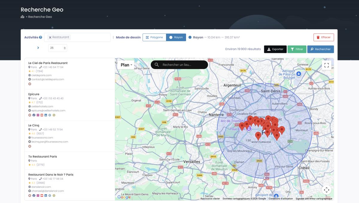
Setting a radius around a point to capture every business inside a catchment area.
Government Open Data
And it's free. Census demographics, crime maps, traffic-incident data, building permits, weather archives — governments give away staggering volumes of spatial data. The skill isn't finding it. It's blending sources to answer your specific question, which is exactly where good location intelligence software shines.
Location Intelligence Tools: From Free to Enterprise
Enterprise GIS licenses start around $15,000 a year. Here's how to capture most of the value for a tiny fraction of that. The location intelligence platform landscape runs from genuinely free to genuinely expensive, and matching the tool to your actual needs is half the battle.
| Tier | Tools | Rough Price | Best For |
|---|---|---|---|
| Free | Google My Maps, QGIS | $0 | Beginners, spatial analysis |
| Mid-range | CARTO, Mapbox, Tableau, Placer.ai | $500–$5,000/mo | Marketing teams, foot-traffic analysis |
| Enterprise | Esri ArcGIS, IBM EIS | $15,000+/yr | Heavy GIS, on-premise needs |
| Lead-gen / data | Scrap.io | From $35/mo | SMBs needing fresh business + contact data |
Free Options
Searching for location intelligence tools free of charge? You have real options. Google My Maps is the gentlest on-ramp there is — build a custom map, drop your data, share with the team. Capped at 10 layers and 2,000 points per layer, but plenty to prove the concept. QGIS is the free, open-source heavyweight: ferociously capable, genuinely hard to learn. If you have a technical person, it punches far above its price (which is zero).
Mid-Range Tools
CARTO was built specifically for location intelligence and marketing teams adore it. Mapbox is for developers who want to build custom mapping products. Tableau with map extensions works if you already live in Tableau. And Placer.ai has carved out a niche in foot-traffic analytics — powerful for retail, though narrow if foot traffic isn't your question.
Enterprise Platforms
Esri ArcGIS is the undisputed king of GIS — staggeringly powerful, steep to learn, priced accordingly. Big organizations with security and on-premise requirements pick it and rarely regret it. IBM's Environmental Intelligence Suite fuses location with weather and AI, which shipping and agriculture firms love. Honest take, though? Most businesses don't need this tier. They need a practical tool that solves one problem cheaply, which is exactly why comparing API costs against scraping matters so much before you commit.
Scrap.io
For lead generation and contact-level business data, Scrap.io fills a gap the GIS giants ignore. From $35/month, you extract live data on any of 225M+ establishments across 195 countries and 4,000+ business categories — names, addresses, coordinates, phone numbers, classified emails, and social profiles. Three things make it click: data is pulled fresh at extraction (no stale database), filters apply before credits are spent (so you never pay for unusable records), and it ships with a REST API, an official MCP connector for AI agents, and a free Chrome extension. Esri won't hand you a verified email. Scrap.io will. Different jobs, different tools.
Stop overpaying for stale data. Start your free 7-day Scrap.io trial — 100 leads included — and pull fresh, filtered business data from any market on the map. Start free →
Building Your First Location Intelligence Strategy
Ready to put location intelligence for business to work? Good. The benefits of location intelligence only show up when you actually operationalize it, and here's where most projects quietly die — they try to boil the ocean and end up with a beautiful dashboard nobody opens. So if you're wondering how to use location intelligence without that fate, here's the five-step path that actually ships results.
Video: How to Turn Your CRM Into a War Machine Using Google Maps Data
Step 1 — Ask clear location questions. Not "understand customers better." That's mush. Try "Which of our stores share customers with a competitor?" or "Where should our next three locations go?" Remember that meal-delivery startup from the intro? One sharp question — "Where do our best customers live?" — was the entire strategy. Specific beats vague every time.
Step 2 — Audit the location data you already own. You're sitting on more than you think: customer addresses, delivery logs, store locations, competitor lists. It's all there, just disconnected. The move is to define your ICP using Google Maps geographic data and then automate location enrichment into your CRM so the context attaches itself. That dusty customer list? Gold, once you view it through a map.
Step 3 — Start small, win fast. Pick one thing that shows a result in 30 days. For B2B, that might mean finding local businesses with no website and pitching them. For retail, analyze foot traffic at your best store and hunt for its twin. Quick win first, empire later.
Step 4 — Pick the right tools. Don't buy enterprise GIS to find local dentists. Match the tool to your budget and skill set — the table above exists for exactly this decision. Most ROI comes from unglamorous wins: better territories, cheaper routes, smarter sites.
Step 5 — Integrate into the daily workflow. The best systems disappear. They auto-enrich new leads, ping sales when a prospect is nearby, and adjust routes on live traffic — instead of becoming yet another dashboard gathering dust. Automate, don't decorate.
You're in good company. Over 50,000 professionals already use Scrap.io for location-based lead generation — and one client extracted 11,734 businesses in 45 minutes. See what your market looks like, free.
Most businesses see ROI in 3 to 6 months. One retailer's pilot paid for itself in six weeks — by simply noticing they were shipping winter coats to Florida in October. Obvious in hindsight. Invisible without the map.
Future Trends: AI, IoT & Real-Time Analytics
Monthly location reports are dead. In 2026, if your insights aren't real-time, they're already wrong by the time you read them. Here's what's actually arriving — not flying cars, real shifts you'll feel within a year or two.
GeoAI is making predictions eerily good. Feed an AI model a candidate address and it'll weigh hundreds of spatial factors to forecast sales within roughly 10% — for a store that doesn't exist yet. It also surfaces patterns no human would catch, like that insurer discovering tree-proximity drove 30% more storm claims. That's the kind of spatial data insights only machine learning extracts from millions of points.
Real-time is the new baseline. During a Super Bowl, a hurricane, or a viral moment, businesses now adjust live — rerouting drivers, shifting inventory, redeploying staff. Edge computing crunches data where it's generated, 5G moves it instantly, and the cloud handles millions of simultaneous lookups. The lag is gone, and so is the excuse.
And privacy is finally getting serious. As capability grows, so does scrutiny. The question shifts from "can we track this?" to "should we?" The winners in 2026 are privacy-first by design — aggregating instead of surveilling, building trust instead of dodging lawsuits. Done right, with public business data, this is entirely legitimate and genuinely transformative. Done wrong, it's a headline you don't want.
Legal & Compliance: Using Location Data Responsibly
Can you legally scrape Google Maps data for location intelligence? Short answer: yes — when it's public business data. The longer answer deserves a paragraph, because this is the section most guides skip and most readers actually worry about.
Business location information that a company voluntarily publishes — its Maps listing, its website address, its public phone number — is public data. Extracting it for B2B prospecting is widely practiced and legally defensible in most jurisdictions. The line you must not cross is consumer surveillance: tracking individuals without consent is a different universe, legally and ethically.
Whatever provider you use should tick these boxes: pulls only public information, is GDPR (EU) and CCPA (California) compliant, makes every data point traceable to its source, and honors deletion requests. Scrap.io meets all four — public business data only, fully GDPR/CCPA compliant, source-traceable by design. Quality over quantity, always: a hundred verified, well-targeted records beat ten thousand scraped blindly. (For the deeper legal walkthrough, here's the dedicated guide on whether scraping Google Maps is legal.)
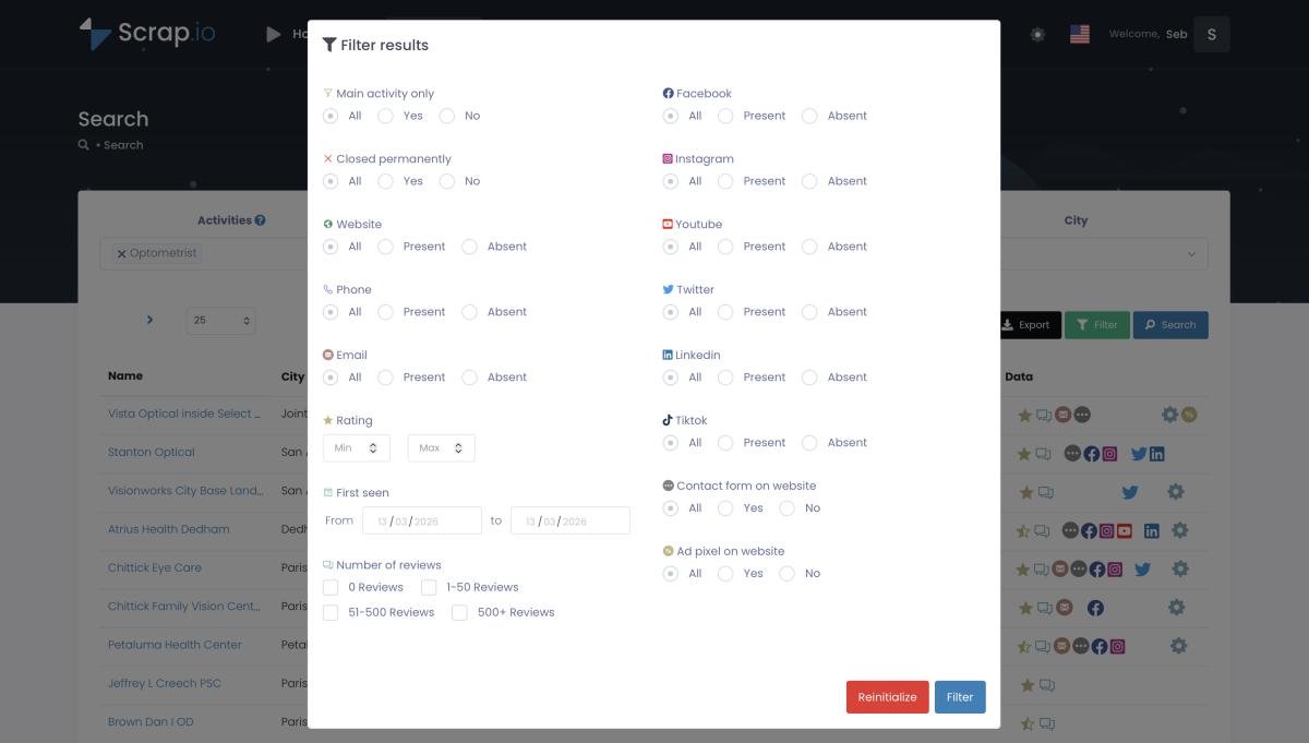
Filtering before extraction — emails, phone type, ratings, website presence — so you only spend credits on usable records.
One more thing worth saying plainly. There's real demand here, not just hype — Quora threads asking "Which companies offer small businesses the best analytics platform for location-based services?" show that small operators are actively hunting for accessible, compliant tools. The market grew up. The compliance has to grow up with it.
Frequently Asked Questions
What is location intelligence in simple terms?
Location intelligence turns geographic data into business insights by analyzing where things happen. It adds a "where" layer to your data, revealing patterns traditional analytics miss — and it's now a $28.7 billion market in 2026.
How is location intelligence different from traditional analytics?
Traditional analytics answers "what" and "when." Location intelligence adds "where" and "why there." Because location influences nearly every other variable, it delivers up to 40% more accurate predictions than tabular analytics alone.
What are the best location intelligence tools for small businesses?
Scrap.io (from $35/month) for fresh Google Maps business and contact data; QGIS (free) for spatial analysis; Google My Maps (free) for visualization; and Esri ArcGIS ($15,000+/year) when you need enterprise-grade GIS.
Can small businesses afford location intelligence?
Yes. Scrap.io offers a free 7-day trial with 100 leads included, then plans from $35/month. Google My Maps and QGIS are free. Most businesses see ROI within 3 to 6 months.
Is it legal to use location data for business intelligence?
Yes, when you use publicly available business data. Scrap.io is GDPR and CCPA compliant and extracts only public business information — never private consumer data.
Take Action: Your Location Intelligence Journey Starts Now
Location intelligence isn't coming. It's here, it's a $28.7 billion market, and it's on track to quadruple by 2035. Ignore the "where" in your data and you're competing with one hand tied behind your back while everyone else reads the map.
You don't need a data-science team or a six-figure software budget. You need sharp questions, the right tool for your scale, and the willingness to put geography back into your decisions. Map your customers. Scan your competition. Run one location-based campaign. Every spatial insight you gain is an edge the company down the street doesn't have.
Try Scrap.io free for 7 days — 100 leads on us. Pull fresh, GDPR-compliant business data from any of 195 countries, filter before you spend a single credit, and turn the "where" into your unfair advantage. Get started free →
Ready to generate leads from Google Maps?
Try Scrap.io for free for 7 days.